Geolocate

Eureka County topographic map

Click on the map to display elevation.

About this map

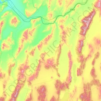
Name: Eureka County topographic map, elevation, terrain.

Location: Eureka County, Nevada, United States (39.16146 -116.60099 41.00144 -115.79486)

Average elevation: 1,878 m

Minimum elevation: 1,324 m

Maximum elevation: 3,470 m

Other topographic maps

Click on a map to view its topography, its elevation and its terrain.

Smith

United States > Nevada > Lyon County

Average elevation: 1,461 m

Groom Lake

United States > Nevada > Lincoln County

Average elevation: 1,355 m

Triangle Mountain

United States > Nevada > Nye County

Average elevation: 1,751 m

Crescent Dunes

United States > Nevada > Nye County

Average elevation: 1,584 m

Ryndon

United States > Nevada > Elko County

Average elevation: 1,603 m

Pleasant Valley

United States > Nevada > Washoe County

Average elevation: 1,587 m

Downeyville

United States > Nevada > Nye County

Average elevation: 1,491 m

Railroad Valley

United States > Nevada

Average elevation: 1,912 m

Henderson

United States > Nevada > Clark County > Henderson

Average elevation: 662 m

Silver Peak

United States > Nevada > Esmeralda County

Average elevation: 1,350 m

Holborn

United States > Nevada > Elko County > Holborn

Average elevation: 1,855 m

Gear up for your next adventure:

🏕️Camping Hammock - Integrated protection for sleeping between trees
🦶Anti-Blister Balm - Prevents friction and hotspots during long ascents
Camping Tent - Weather-resistant tents suitable for 2 to 6 people
🎒Fully Waterproof Backpack - Total protection for photography gear and electronics
🧢Sun Protection Cap - Breathable cap to protect from sun exposure

As an Amazon Associate, this site earns from qualifying purchases at no extra cost to you.