Geolocate

The Notch topographic map

Click on the map to display elevation.

About this map

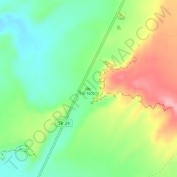
Name: The Notch topographic map, elevation, terrain.

Location: The Notch, Wayne County, Utah, United States (38.44901 -110.68037 38.44911 -110.68027)

Average elevation: 1,409 m

Minimum elevation: 1,349 m

Maximum elevation: 1,500 m

Other topographic maps

Click on a map to view its topography, its elevation and its terrain.

Teasdale

United States > Utah > Wayne County > Teasdale

Average elevation: 2,197 m

Loa

United States > Utah > Wayne County

Average elevation: 2,158 m

Torrey

United States > Utah > Wayne County

Average elevation: 2,089 m

Hanksville

United States > Utah > Wayne County

Average elevation: 1,330 m

Gear up for your next adventure:

Camping Essentials - All-in-one gear for a comfortable camping trip
🗺️Topographic Maps - Detailed maps to explore trails, mountains, and wilderness areas
🧴Sunscreen SPF - Broad-spectrum sunscreen for outdoor activities
🔥Camping Stove - Portable stoves to cook outdoors with ease
🔋Emergency Crank Radio - Weather alerts and power without needing batteries

As an Amazon Associate, this site earns from qualifying purchases at no extra cost to you.