Geolocate

Hanksville topographic map

Click on the map to display elevation.

About this map

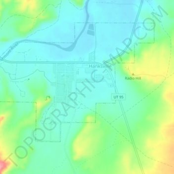
Name: Hanksville topographic map, elevation, terrain.

Location: Hanksville, Wayne County, Utah, 84734, United States (38.35985 -110.73093 38.38176 -110.69372)

Average elevation: 1,330 m

Minimum elevation: 1,302 m

Maximum elevation: 1,383 m

Other topographic maps

Click on a map to view its topography, its elevation and its terrain.

Factory Butte

United States > Utah > Wayne County

Average elevation: 1,517 m

Skyline Rim Overlook

United States > Utah > Wayne County

Average elevation: 1,439 m

Fruita

United States > Utah > Wayne County

Average elevation: 1,803 m

Gear up for your next adventure:

Family Camping Tent - Spacious tent suitable for family camping trips
🧤Thermal Hiking Gloves - Grip-enhanced gloves for cold-weather altitude trekking
💧Collapsible Water Bottle - Space-saving water bottle for outdoor activities
🛌Down Sleeping Bag - Superior warmth-to-weight ratio for cold nights
🛶Kayak Accessories - Essential gear for safe and fun kayaking adventures

As an Amazon Associate, this site earns from qualifying purchases at no extra cost to you.