Geolocate

Torrey topographic map

Click on the map to display elevation.

About this map

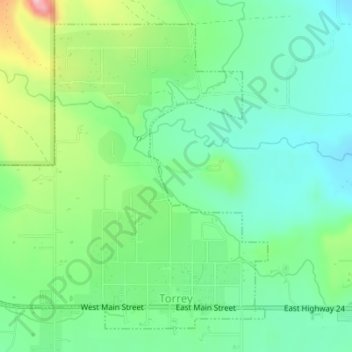
Name: Torrey topographic map, elevation, terrain.

Location: Torrey, Wayne County, Utah, United States (38.29533 -111.44153 38.32076 -111.41151)

Average elevation: 2,089 m

Minimum elevation: 2,032 m

Maximum elevation: 2,202 m

Other topographic maps

Click on a map to view its topography, its elevation and its terrain.

The Notch

United States > Utah > Wayne County

Average elevation: 1,409 m

Teasdale

United States > Utah > Wayne County

Average elevation: 2,200 m

Factory Butte

United States > Utah > Wayne County

Average elevation: 1,517 m

Skyline Rim Overlook

United States > Utah > Wayne County

Average elevation: 1,439 m

Fruita

United States > Utah > Wayne County

Average elevation: 1,803 m

Gear up for your next adventure:

🎒Hiking Backpack - Lightweight and ergonomic backpacks for day hikes or multi-day treks
💧Filtered Water Bottle - Safe drinking water on the go
❄️Traction Ice Cleats - Slip-on spikes for icy trails and winter hiking
🔦LED Headlamp - Hands-free lighting for early morning starts or late finishes
🥫Freeze-Dried Meals - Lightweight, high-calorie nutrition for multi-day treks

As an Amazon Associate, this site earns from qualifying purchases at no extra cost to you.