Geolocate

Colmurano topographic map

Click on the map to display elevation.

About this map

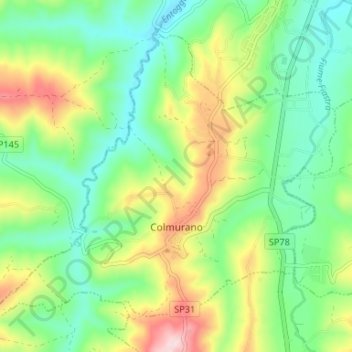
Name: Colmurano topographic map, elevation, terrain.

Location: Colmurano, Macerata, Marche, Italy (43.15101 13.32090 43.19062 13.38689)

Average elevation: 298 m

Minimum elevation: 200 m

Maximum elevation: 484 m

Other topographic maps

Click on a map to view its topography, its elevation and its terrain.

Paganico

Italy > Marche > Macerata > Camerino

Average elevation: 546 m

San Martino

Italy > Marche > Macerata > Sant'Angelo in Pontano

Average elevation: 274 m

Anselmi

Italy > Marche > Macerata > Monte San Martino

Average elevation: 405 m

Vecciola di Sopra

Italy > Marche > Macerata > Sarnano

Average elevation: 529 m

Aurora

Italy > Marche > Macerata > Civitanova Marche

Average elevation: 24 m

Vestignano

Italy > Marche > Macerata > Caldarola

Average elevation: 630 m

Gear up for your next adventure:

Camping Groundsheet - Protect your tent from moisture and dirt
📷Outdoor Action Camera - Capture high-elevation views and rugged adventures
🧥Ultralight Puffy Jacket - Maximum warmth that packs down to the size of an orange
🧥Fleece Jacket - Warm and lightweight jacket for layering
Lightweight Backpacking Tent - Compact tent for efficient hiking trips

As an Amazon Associate, this site earns from qualifying purchases at no extra cost to you.