Geolocate

Lodi topographic map

Click on the map to display elevation.

About this map

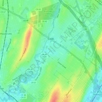
Name: Lodi topographic map, elevation, terrain.

Location: Lodi, Bergen County, New Jersey, 07644, United States (40.86144 -74.09864 40.89509 -74.06415)

Average elevation: 19 m

Minimum elevation: 1 m

Maximum elevation: 52 m

Other topographic maps

Click on a map to view its topography, its elevation and its terrain.

Ridgewood

United States > New Jersey > Bergen County

Average elevation: 56 m

Darlington

United States > New Jersey > Bergen County > Mahwah

Average elevation: 129 m

Drag Hill

United States > New Jersey > Bergen County > Mahwah

Average elevation: 252 m

Stag Hill

United States > New Jersey > Bergen County > Mahwah

Average elevation: 204 m

Green Hill

United States > New Jersey > Bergen County > Mahwah

Average elevation: 175 m

Fardale

United States > New Jersey > Bergen County > Mahwah

Average elevation: 124 m

Cragmere

United States > New Jersey > Bergen County > Mahwah

Average elevation: 136 m

Teterboro

United States > New Jersey > Bergen County > Teterboro

Average elevation: 12 m

Westwood

United States > New Jersey > Bergen County > Westwood > Westwood

Average elevation: 31 m

Gear up for your next adventure:

🧦Thermal Socks - Warm socks for winter hiking or camping
🧳Compression Sacks - Maximize space in your backpack by shrinking gear
🧢Sun Protection Cap - Breathable cap to protect from sun exposure
🔭Compact Monocular - One-handed bird watching and trail spotting
🥾Trekking Poles - Adjustable trekking poles to reduce knee stress and improve stability

As an Amazon Associate, this site earns from qualifying purchases at no extra cost to you.