
Mansel Island topographic map
Click on the map to display elevation.
Mansel Island
Mansel Island (Inuktitut: Pujjunaq), a member of the Arctic Archipelago, is an uninhabited island in Qikiqtaaluk Region, Nunavut. It is located in Hudson Bay off Quebec's Ungava Peninsula. At 3,180 km2 (1,230 sq mi) in size, it is the 159th largest island in the world, and Canada's 28th largest island. Its topography features a gently undulating limestone lowland with elevations not exceeding 100 m.
About this map
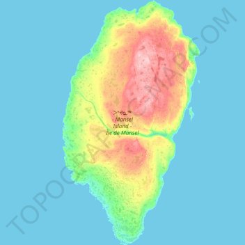
Name: Mansel Island topographic map, elevation, terrain.
Location: Mansel Island, Nunavut, Canada (61.57142 -80.27325 62.41569 -79.26067)
Average elevation: 17 m
Minimum elevation: -3 m
Maximum elevation: 126 m
Nunavut trails, hiking, mountain biking, running and outdoor activities
Other topographic maps
Click on a map to view its topography, its elevation and its terrain.
Arctic Bay
Canada > Nunavut > Qikiqtaaluk Region
Arctic Bay experiences a tundra climate (Köppen: ET) like most northern Canadian territories at low elevations, with long, very cold winters and short, cool to cold summers. July is the only month with an average low temperature above freezing. Its climate does not differ from the more severe subarctic…
Average elevation: 160 m
Mount Odin
Canada > Nunavut > Qikiqtaaluk Region
Mount Odin is the highest mountain within the Baffin Mountains as well as the fifth-highest in the Arctic Cordillera. It has a topographic prominence of 2,147 m (7,044 ft), greater than any other mountain within the Baffin Mountains and on Baffin Island, making Odin the third-highest mountain in Nunavut by…
Average elevation: 1,440 m
Thor Peak
Canada > Nunavut > Qikiqtaaluk Region
Mount Thor, officially gazetted as Thor Peak (Inuktitut: ᙯᕐᓱᐊᓗᒃ Qaisualuk "huge bedrock"[3][4] or Inuktitut: ᑭᒍᑎᙳᐊᖅ Kigutinnguaq "tooth-like"[3][5]), is a mountain with an elevation of 1,675 m (5,495 ft) located in Auyuittuq National Park, on Baffin Island, Nunavut, Canada. The mountain…
Average elevation: 690 m
Thor Peak
Canada > Nunavut > Qikiqtaaluk Region
Mount Thor, officially gazetted as Thor Peak (Inuktitut syllabics: ᙯᕐᓱᐊᓗᒃ, Inuktitut: Qaisualuk "huge bedrock", or Kigutinnguaq "tooth-like"), in Nunavut, Canada, is a mountain with an elevation of 1,675 m (5,495 ft) located in Auyuittuq National Park, on Baffin Island. The mountain is located 46…
Average elevation: 690 m
Thor Peak
Canada > Nunavut > Qikiqtaaluk Region
Mount Thor, officially gazetted as Thor Peak (Inuktitut: ᙯᕐᓱᐊᓗᒃ Qaisualuk "huge bedrock" or Inuktitut: ᑭᒍᑎᙳᐊᖅ Kigutinnguaq "tooth-like"), is a mountain with an elevation of 1,675 m (5,495 ft) located in Auyuittuq National Park, on Baffin Island, Nunavut, Canada. The mountain is located…
Average elevation: 690 m