Geolocate

Elgin County topographic map

Click on the map to display elevation.

About this map

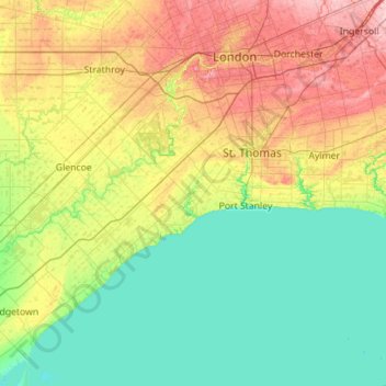
Name: Elgin County topographic map, elevation, terrain.

Location: Elgin County, Southwestern Ontario, Ontario, Canada (42.43591 -81.83505 42.91256 -80.71715)

Average elevation: 212 m

Minimum elevation: 169 m

Maximum elevation: 328 m

Ontario trails, hiking, mountain biking, running and outdoor activities

Other topographic maps

Click on a map to view its topography, its elevation and its terrain.

Toronto

Canada > Ontario > Toronto

Despite its deep ravines, Toronto is not remarkably hilly, but its elevation does increase steadily away from the lake. Elevation differences range from 76.5 metres (251 ft) above sea level at the Lake Ontario shore to 209 m (686 ft) ASL near the York University grounds in the city's north end at the…

Average elevation: 113 m

Hamilton

Canada > Ontario > Hamilton

Average elevation: 181 m

London

Canada > Ontario > London > London

London has a humid continental climate (Köppen Dfb), though due to its downwind location relative to Lake Huron and elevation changes across the city, it is virtually on the Dfa/Dfb (hot summer) boundary favouring the former climate zone to the southwest of the confluence of the South and North Thames Rivers,…

Average elevation: 268 m

Guelph

Canada > Ontario > Guelph

This region of Ontario has cold winters and warm, humid summers, falling into the Köppen climate classification Dfb zone, with moderately high rainfall and snowfall. It is generally a couple of degrees cooler than lower elevation regions on the Great Lakes shorelines, especially so in winter, the exception…

Average elevation: 344 m

Kawartha Lakes

Canada > Ontario > Kawartha Lakes

Average elevation: 269 m

St. Thomas

Canada > Ontario > St. Thomas

Average elevation: 231 m

Peterborough

Canada > Ontario > Peterborough

Peterborough's topography is largely defined by land formations created by the receding Wisconsian glaciers 10,000–15,000 years ago. The South End and Downtown portions of the City sit on what was the bottom of the glacial Lake Peterborough—part of a glacial spillway created when glacial meltwaters from…

Average elevation: 235 m

Niagara Escarpment

Canada > Ontario > Hamilton

Average elevation: 162 m

Belleville

Canada > Ontario > Belleville

Average elevation: 107 m

Barry's Bay

Canada > Ontario > Renfrew County > Madawaska Valley

Average elevation: 327 m

Haliburton

Canada > Ontario > Haliburton County > Dysart et al

Average elevation: 370 m

Parry Sound

Canada > Ontario

Average elevation: 235 m

Pelee Island

Canada > Ontario

Average elevation: 173 m

Windsor

Canada > Ontario > Windsor

Average elevation: 185 m

Alliston

Canada > Ontario > Simcoe County

Average elevation: 233 m

Stratford

Canada > Ontario > Stratford

Average elevation: 356 m

Ennismore

Canada > Ontario > Peterborough County > Selwyn

Average elevation: 271 m

Port Perry

Canada > Ontario > Durham Region > Scugog

Average elevation: 263 m

Guelph Lake

Canada > Ontario > Guelph/Eramosa

Average elevation: 350 m

Fenelon Falls

Canada > Ontario > Kawartha Lakes

Average elevation: 269 m

New Hamburg

Canada > Ontario > Region of Waterloo > Wilmot

Average elevation: 351 m

Grand Bend

Canada > Ontario > Lambton County > Lambton Shores

Average elevation: 183 m

Port Elgin

Canada > Ontario > Bruce County

Average elevation: 199 m

Centennial Park

Canada > Ontario > Toronto

Average elevation: 151 m

Niagara Escarpment

Canada > Ontario

Average elevation: 299 m

Lake of Bays

Canada > Ontario > Muskoka District

Average elevation: 341 m

Chippawa

Canada > Ontario > Niagara Region > Niagara Falls > Chippawa

Average elevation: 174 m

Thomasburg

Canada > Ontario > Hastings County > Tweed

Average elevation: 160 m

Haliburton

Canada > Ontario

Average elevation: 358 m

Kenora

Canada > Ontario

Average elevation: 182 m

Prince Edward

Canada > Ontario

Average elevation: 118 m

Perth

Canada > Ontario

Average elevation: 313 m

Lambton

Canada > Ontario

Average elevation: 188 m

Foymount

Canada > Ontario > Renfrew County > Bonnechere Valley

The location is also popular for amateur astronomers given the high altitude and low levels of artificial light.

Average elevation: 432 m

Essex

Canada > Ontario

Average elevation: 193 m

Lac Seul

Canada > Ontario

Average elevation: 365 m

South Porcupine

Canada > Ontario > Cochrane District > Timmins

Average elevation: 300 m

Speed River

Canada > Ontario > Guelph/Eramosa

Average elevation: 352 m

Harlem Shoal

Canada > Ontario

Average elevation: 175 m

St. Johns

Canada > Ontario

Average elevation: 205 m

Niagara Escarpment

Canada > Ontario > Burlington

Average elevation: 216 m

Quetico Provincial Park

Canada > Ontario

Average elevation: 432 m

Ohsweken

Canada > Ontario

Average elevation: 208 m

Sagamok

Canada > Ontario

Average elevation: 210 m

Pinehurst Lake

Canada > Ontario

Average elevation: 295 m

Docker Lake

Canada > Ontario

Average elevation: 377 m

Oneida Nation of the Thames

Canada > Ontario

Average elevation: 224 m

Bigwin Island

Canada > Ontario

Average elevation: 328 m

Upper Pergeon Lake

Canada > Ontario

Average elevation: 215 m

York River

Canada > Ontario

Average elevation: 397 m

Kawartha Lakes (city)

Canada > Ontario

Average elevation: 274 m

Fort Albany

Canada > Ontario > Cochrane District

Average elevation: 9 m

Quinte West (city)

Canada > Ontario

Average elevation: 160 m

London

Canada > Ontario

London has a humid continental climate (Köppen Dfb), though due to its downwind location relative to Lake Huron and elevation changes across the city, it is virtually on the Dfa/Dfb (hot summer) boundary favouring the former climate zone to the southwest of the confluence of the South and North Thames Rivers,…

Average elevation: 269 m

Lambton

Canada > Ontario

Average elevation: 191 m

Algoma District

Canada > Ontario

Average elevation: 360 m

London (city)

Canada > Ontario

Average elevation: 239 m

Bob's Lake

Canada > Ontario > Cochrane District > Timmins > Porcupine

Average elevation: 287 m

Brantford

Canada > Ontario > Brantford

Average elevation: 238 m

Lindsay

Canada > Ontario > Kawartha Lakes

Average elevation: 268 m

Minden

Canada > Ontario > Haliburton County > Minden Hills

Average elevation: 320 m

Westport

Canada > Ontario > Leeds and Grenville Counties

Average elevation: 146 m

Dundas

Canada > Ontario > Hamilton > Dundas

Dundas /ˈdʌnˌdæs/ is a community and former town in Hamilton, Ontario, Canada. It is nicknamed the Valley Town because of its topographical location at the bottom of the Niagara Escarpment on the western edge of Lake Ontario. The population has been stable for decades at about twenty thousand, largely…

Average elevation: 171 m

Night Hawk Lake

Canada > Ontario > Timmins

Average elevation: 275 m

Kelso Conservation Area

Canada > Ontario > Milton

Average elevation: 279 m

Almonte

Canada > Ontario > Lanark County > Mississippi Mills

Average elevation: 137 m

Dunlop Lake

Canada > Ontario > Elliot Lake

Average elevation: 379 m

Combermere

Canada > Ontario > Renfrew County > Madawaska Valley

Average elevation: 318 m

Lucan

Canada > Ontario > Middlesex County > Lucan Biddulph

Average elevation: 301 m

Arden

Canada > Ontario > Frontenac County > Central Frontenac

Average elevation: 200 m

Millbrook

Canada > Ontario > Peterborough County > Cavan-Monaghan

Peterborough's topography is largely defined by land formations created by the receding Wisconsian glaciers 10,000–15,000 years ago. The South End and Downtown portions of the city sit on what was the bottom of the glacial Lake Peterborough—part of a glacial spillway created when glacial meltwaters from…

Average elevation: 250 m

Wolseley Bay

Canada > Ontario > French River

Average elevation: 198 m

Mannheim

Canada > Ontario > Region of Waterloo > Wilmot > Mannheim

Average elevation: 358 m

Lions' Head Lookout

Canada > Ontario > Bruce County

Average elevation: 198 m

Giants Tomb Island

Canada > Ontario > Simcoe County

Average elevation: 178 m

Chapleau

Canada > Ontario > Sudbury District > Chapleau Township

Average elevation: 444 m

Conroy Pit

Canada > Ontario > Ottawa

Average elevation: 91 m

Inglewood

Canada > Ontario > Peel Region > Caledon

Average elevation: 308 m

Grassy Narrows

Canada > Ontario > Kenora District

Average elevation: 327 m

Ardoch

Canada > Ontario > Frontenac County > North Frontenac

Average elevation: 261 m

Nobleton

Canada > Ontario > York Region > King

Average elevation: 264 m

Gear up for your next adventure:

🧥Waterproof Hiking Jacket - Protect yourself from rain and wind while hiking
🐕Hiking Dog Pack - Let your canine companion carry their own water and food
🧴Sunscreen SPF - Broad-spectrum sunscreen for outdoor activities
🥾Light Hiking Boots - Lightweight and comfortable boots for day hikes
🧢Beanie Hat - Keep your head warm in cold weather

As an Amazon Associate, this site earns from qualifying purchases at no extra cost to you.