Geolocate

Torla-Ordesa topographic map

Click on the map to display elevation.

About this map

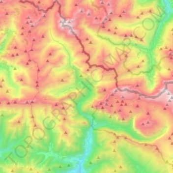
Name: Torla-Ordesa topographic map, elevation, terrain.

Location: Torla-Ordesa, Sobrarbe, Huesca, Aragon, Spain (42.59544 -0.20765 42.79845 0.02144)

Average elevation: 1,999 m

Minimum elevation: 877 m

Maximum elevation: 3,294 m

Other topographic maps

Click on a map to view its topography, its elevation and its terrain.

Escuaín

Spain > Aragon > Sobrarbe > Puértolas

Average elevation: 1,441 m

Saravillo

Spain > Aragon > Sobrarbe > Plan

Average elevation: 1,416 m

Palo

Spain > Aragon > Sobrarbe > Palo > Palo

Average elevation: 737 m

Bielsa

Spain > Aragon > Sobrarbe > Bielsa > Bielsa

Average elevation: 1,403 m

Gear up for your next adventure:

🔋Lithium AA Batteries - Long-lasting power that performs in extreme cold
🧰Emergency Multi-Tool - Compact multi-tool for outdoor survival
🔥Camping Stove - Portable stoves to cook outdoors with ease
🚑Survival Whistle - Signal for help across long distances in mountains
Tent Footprint - Protect tent floor and increase durability

As an Amazon Associate, this site earns from qualifying purchases at no extra cost to you.