
Drakelow topographic map
Click on the map to display elevation.
About this map
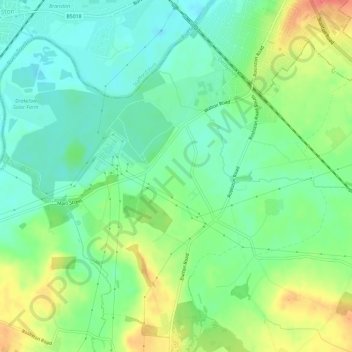
Name: Drakelow topographic map, elevation, terrain.
Average elevation: 61 m
Minimum elevation: 41 m
Maximum elevation: 95 m
Other topographic maps
Click on a map to view its topography, its elevation and its terrain.
Robin Wood
United Kingdom > England > Derbyshire > South Derbyshire > Stanton by Bridge CP
Average elevation: 92 m
Pistern Hill
United Kingdom > England > Derbyshire > South Derbyshire > Smisby
Average elevation: 152 m
Repton Shrubs
United Kingdom > England > Derbyshire > South Derbyshire > Repton CP
Average elevation: 110 m
Newhall Wood
United Kingdom > England > Derbyshire > South Derbyshire > Newhall
Average elevation: 87 m
Staunton Harold Reservoir
United Kingdom > England > Derbyshire > South Derbyshire > Melbourne CP
Average elevation: 93 m
Linton Heath
United Kingdom > England > Derbyshire > South Derbyshire > Linton
Average elevation: 101 m
Foremark Reservoir
United Kingdom > England > Derbyshire > South Derbyshire > Foremark CP
Average elevation: 119 m
Botany Bay
United Kingdom > England > Derbyshire > South Derbyshire > Rosliston
Average elevation: 95 m
Mercia Marina
United Kingdom > England > Derbyshire > South Derbyshire > Willington CP
Average elevation: 51 m
Gorsey Leys
United Kingdom > England > Derbyshire > South Derbyshire > Stanton by Bridge CP
Average elevation: 101 m
Elvaston Castle
United Kingdom > England > Derbyshire > South Derbyshire > Elvaston
Average elevation: 41 m
Calke Park (National Trust)
United Kingdom > England > Derbyshire > South Derbyshire > Calke CP
Average elevation: 98 m