
Hill Covert topographic map
Click on the map to display elevation.
About this map
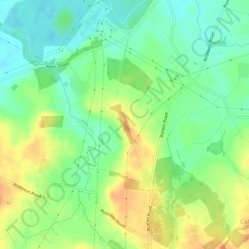
Name: Hill Covert topographic map, elevation, terrain.
Average elevation: 65 m
Minimum elevation: 47 m
Maximum elevation: 88 m
Other topographic maps
Click on a map to view its topography, its elevation and its terrain.
Pistern Hill
United Kingdom > England > Derbyshire > South Derbyshire > Smisby
Average elevation: 152 m
Hartshorne
United Kingdom > England > Derbyshire > South Derbyshire > Swadlincote
Average elevation: 132 m
Linton Heath
United Kingdom > England > Derbyshire > South Derbyshire > Linton
Average elevation: 101 m
Woodville
United Kingdom > England > Derbyshire > South Derbyshire > Swadlincote
Average elevation: 132 m
Botany Bay
United Kingdom > England > Derbyshire > South Derbyshire > Rosliston
Average elevation: 95 m
Gorsey Leys
United Kingdom > England > Derbyshire > South Derbyshire > Stanton by Bridge CP
Average elevation: 101 m