Geolocate

Datchet topographic map

Click on the map to display elevation.

About this map

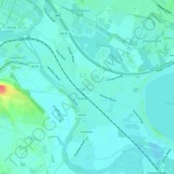
Name: Datchet topographic map, elevation, terrain.

Location: Datchet, Berkshire, England, United Kingdom (51.46905 -0.59569 51.49943 -0.54900)

Average elevation: 20 m

Minimum elevation: 12 m

Maximum elevation: 64 m

Other topographic maps

Click on a map to view its topography, its elevation and its terrain.

Slough

United Kingdom > England > Berkshire

Average elevation: 34 m

Wickham

United Kingdom > England > Berkshire

Average elevation: 134 m

Maidenhead

United Kingdom > England > Berkshire

Average elevation: 41 m

Ascot

United Kingdom > England > Berkshire

Average elevation: 72 m

Fifield

United Kingdom > England > Berkshire

Average elevation: 33 m

Arborfield

United Kingdom > England > Berkshire

Average elevation: 57 m

Reading

United Kingdom > England > Berkshire > Reading

Average elevation: 58 m

Ascot

United Kingdom > England > Berkshire

Average elevation: 72 m

Gear up for your next adventure:

🧥Thermal Layer - Insulating layer for cold outdoor conditions
🧊Insulated Water Bottle - Keeps drinks cold in summer and prevents freezing in winter
👟Trail Running Shoes - Agile footwear for fast-paced topographic exploration
🥾Approach Boots - Comfortable boots for hiking and climbing approaches
Camping Coffee Maker - Brew fresh coffee anywhere on the topographic map

As an Amazon Associate, this site earns from qualifying purchases at no extra cost to you.