Geolocate

Arborfield topographic map

Click on the map to display elevation.

About this map

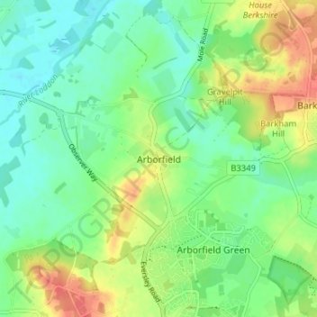
Name: Arborfield topographic map, elevation, terrain.

Location: Arborfield, Berkshire, England, RG2 9PG, United Kingdom (51.37634 -0.92543 51.41634 -0.88543)

Average elevation: 57 m

Minimum elevation: 37 m

Maximum elevation: 90 m

Other topographic maps

Click on a map to view its topography, its elevation and its terrain.

Bucklebury

United Kingdom > England > Berkshire

Average elevation: 99 m

Aldworth

United Kingdom > England > Berkshire > Aldworth

Average elevation: 148 m

Lambourn

United Kingdom > England > Berkshire

Average elevation: 177 m

Datchet

United Kingdom > England > Berkshire

Average elevation: 20 m

Midgham

United Kingdom > England > Berkshire > West Berkshire

Average elevation: 90 m

River Loddon

United Kingdom > England > Berkshire > Winnersh

Average elevation: 68 m

Thatcham

United Kingdom > England > Berkshire

Average elevation: 94 m

Reading

United Kingdom > England > Berkshire > Reading

Average elevation: 58 m

Bracknell

United Kingdom > England > Berkshire

Average elevation: 80 m

Sonning

United Kingdom > England > Berkshire

Average elevation: 45 m

Gear up for your next adventure:

🧴Sunscreen SPF - Broad-spectrum sunscreen for outdoor activities
🔨Vehicle Emergency Tool - Safety tool for remote road trips to trailheads
🎒Fully Waterproof Backpack - Total protection for photography gear and electronics
🥾Durable Hiking Shoes - Long-lasting shoes for frequent hiking
🥫Freeze-Dried Meals - Lightweight, high-calorie nutrition for multi-day treks

As an Amazon Associate, this site earns from qualifying purchases at no extra cost to you.