Geolocate

Ascot topographic map

Click on the map to display elevation.

About this map

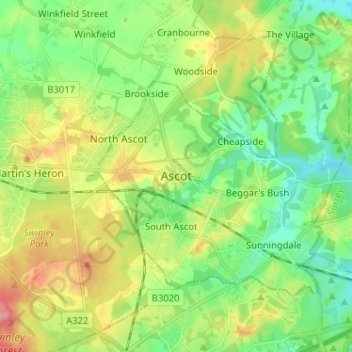
Name: Ascot topographic map, elevation, terrain.

Location: Ascot, Berkshire, England, SL5 7FW, United Kingdom (51.37013 -0.70802 51.45013 -0.62802)

Average elevation: 72 m

Minimum elevation: 37 m

Maximum elevation: 130 m

Other topographic maps

Click on a map to view its topography, its elevation and its terrain.

Bracknell

United Kingdom > England > Berkshire

Average elevation: 80 m

Sonning

United Kingdom > England > Berkshire

Average elevation: 45 m

River Loddon

United Kingdom > England > Berkshire > Winnersh

Average elevation: 68 m

Thatcham

United Kingdom > England > Berkshire

Average elevation: 94 m

Reading

United Kingdom > England > Berkshire > Reading

Average elevation: 58 m

Midgham

United Kingdom > England > Berkshire > West Berkshire

Average elevation: 90 m

Aldworth

United Kingdom > England > Berkshire > Aldworth

Average elevation: 148 m

Bucklebury

United Kingdom > England > Berkshire

Average elevation: 99 m

Lambourn

United Kingdom > England > Berkshire

Average elevation: 177 m

Datchet

United Kingdom > England > Berkshire

Average elevation: 20 m

Gear up for your next adventure:

🥾Durable Hiking Shoes - Long-lasting shoes for frequent hiking
🎒Fully Waterproof Backpack - Total protection for photography gear and electronics
🌡️Emergency Mylar Blankets - Compact thermal protection for unexpected nights outdoors
Lightweight Backpacking Tent - Compact tent for efficient hiking trips
🧰Multitool Knife - Compact and versatile tool for outdoor use

As an Amazon Associate, this site earns from qualifying purchases at no extra cost to you.