
Make a donation
Gear up for your next adventure:
As an Amazon Associate, this site earns from qualifying purchases at no extra cost to you.
Buckingham Campground topographic map
Click on the map to display elevation.
Make a donation
Gear up for your next adventure:
As an Amazon Associate, this site earns from qualifying purchases at no extra cost to you.
About this map
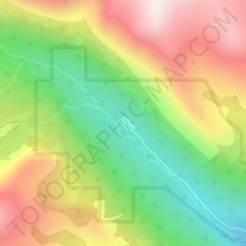
Name: Buckingham Campground topographic map, elevation, terrain.
Average elevation: 3,338 m
Minimum elevation: 2,980 m
Maximum elevation: 3,746 m
Make a donation
Gear up for your next adventure:
As an Amazon Associate, this site earns from qualifying purchases at no extra cost to you.
Other topographic maps
Click on a map to view its topography, its elevation and its terrain.
Nederland
United States > Colorado > Boulder County
In 1873 the Caribou Mine, at an elevation of roughly 10,000 feet (3,000 m) and 6 miles (10 km) northwest of the town, was sold to the Mining Company Nederland from the Netherlands. The high elevation meant fierce winds and deep winter snow, so the new owners of the mine decided that it was beneficial to bring…
Average elevation: 2,578 m
Lafayette
United States > Colorado > Boulder County > Lafayette > Lafayette
Average elevation: 1,597 m
Boulder
United States > Colorado > Boulder County > Boulder
Boulder is located at the base of the foothills of the Rocky Mountains, at an elevation of 5,430 feet (1,655 m) above sea level. Boulder is 25 miles (40 km) northwest of the Colorado State Capitol in Denver. It is home of the main campus of the University of Colorado, the state's largest university.
Average elevation: 1,977 m
University of Colorado Boulder (Williams Village)
United States > Colorado > Boulder County > Boulder
Average elevation: 1,634 m
Make a donation
Gear up for your next adventure:
As an Amazon Associate, this site earns from qualifying purchases at no extra cost to you.
Fredrick Law Olmsted, Jr. Park
United States > Colorado > Boulder County > Boulder
Average elevation: 1,664 m
Make a donation
Gear up for your next adventure:
As an Amazon Associate, this site earns from qualifying purchases at no extra cost to you.
Jamestown
United States > Colorado > Boulder County
Jamestown is in central Boulder County at 40°6′56″N 105°23′15″W / 40.11556°N 105.38750°W / 40.11556; -105.38750 (40.115485, −105.387531). It lies along James Creek within the Front Range of the Colorado Rockies, with access via James Canyon Drive, which leads east 8 miles (13 km) to U.S.…
Average elevation: 2,271 m
Make a donation
Gear up for your next adventure:
As an Amazon Associate, this site earns from qualifying purchases at no extra cost to you.
National Center for Atmospheric Research
United States > Colorado > Boulder County > Boulder
Average elevation: 1,816 m
Make a donation
Gear up for your next adventure:
As an Amazon Associate, this site earns from qualifying purchases at no extra cost to you.
Make a donation
Gear up for your next adventure:
As an Amazon Associate, this site earns from qualifying purchases at no extra cost to you.
Seven Hills
United States > Colorado > Boulder County > Boulder > Seven Hills
Average elevation: 1,985 m
Make a donation
Gear up for your next adventure:
As an Amazon Associate, this site earns from qualifying purchases at no extra cost to you.