
South Valley topographic map
Click on the map to display elevation.
About this map
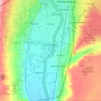
Name: South Valley topographic map, elevation, terrain.
Average elevation: 1,552 m
Minimum elevation: 1,492 m
Maximum elevation: 1,664 m
Other topographic maps
Click on a map to view its topography, its elevation and its terrain.
Albuquerque
United States > New Mexico > Bernalillo County > Albuquerque
Located in north-central New Mexico, Albuquerque serves as the county seat of Bernalillo County. To its east are the Sandia–Manzano Mountains, Rio Grande flows north to south through its center, while the West Mesa and Petroglyph National Monument make up the western part of the city. Albuquerque has one of…
Average elevation: 1,671 m