
Lanzhou topographic map
Click on the map to display elevation.
About this map
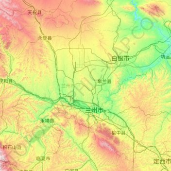
Name: Lanzhou topographic map, elevation, terrain.
Location: Lanzhou, Gansu, China (35.57316 102.59567 36.99863 104.57455)
Average elevation: 2,095 m
Minimum elevation: 1,337 m
Maximum elevation: 4,195 m
Other topographic maps
Click on a map to view its topography, its elevation and its terrain.
Xiahe
China > Gansu > Xiahe County > Labrang
Xiahe (Sangqu) is found in the southern portion of Gansu province, along the western border with Qinghai province. It lies along the Daxia and Zhao rivers. It is on the northeast edge of the Tibetan Plateau. The average elevation is 2,900 to 3,100 m (9,500 to 10,200 ft) with the highest being 4,636 m (15,210…
Average elevation: 3,366 m
Gannan
China > Gansu > Hezuo City > Tongqin
Gannan, as illustrated by this chart for Xiahe, has an alpine subarctic climate (Köppen Dwc) that grades into an alpine climate (ETH) at the highest elevations. The climate is characterised by mild, rainy summers and frigid, but dry and sunny, winters.
Average elevation: 3,075 m