Geolocate

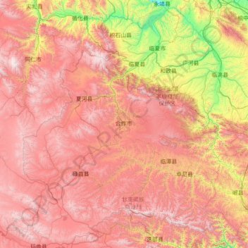
Gannan topographic map

Click on the map to display elevation.

Gannan

Gannan, as illustrated by this chart for Xiahe, has an alpine subarctic climate (Köppen Dwc) that grades into an alpine climate (ETH) at the highest elevations. The climate is characterised by mild, rainy summers and frigid, but dry and sunny, winters.

Wikipedia (CC-BY-SA 3.0)

About this map

Name: Gannan topographic map, elevation, terrain.

Location: Gannan, Tongqin, Hezuo City, Gannan Tibetan Autonomous Prefecture, Gansu, 747000, China (33.98453 101.91059 35.98453 103.91059)

Average elevation: 3,075 m

Minimum elevation: 1,621 m

Maximum elevation: 4,740 m

Gear up for your next adventure:

🛁Quick-Dry Microfiber Towel - Space-saving towel that dries rapidly on the move
Camping Coffee Maker - Brew fresh coffee anywhere on the topographic map
🌬️Windproof Camp Stove - Efficient cooking even on exposed mountain peaks
🧥Softshell Jacket - Windproof and breathable jacket for hiking
🥾Light Hiking Boots - Lightweight and comfortable boots for day hikes

As an Amazon Associate, this site earns from qualifying purchases at no extra cost to you.