Geolocate

Mulshi topographic map

Click on the map to display elevation.

About this map

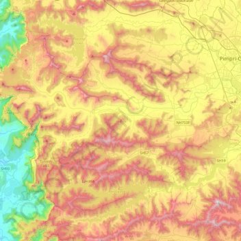
Name: Mulshi topographic map, elevation, terrain.

Location: Mulshi, Pune, Maharashtra, India (18.35147 73.32271 18.67793 73.78538)

Average elevation: 657 m

Minimum elevation: 42 m

Maximum elevation: 1,310 m

Other topographic maps

Click on a map to view its topography, its elevation and its terrain.

Daund

India > Maharashtra > Daund

Average elevation: 519 m

Elphinstone Point

India > Maharashtra > Mahabaleshwar > Dare

Average elevation: 888 m

Kansai

India > Maharashtra > Shahade

Average elevation: 211 m

Nittur

India > Maharashtra > Chandgad

Average elevation: 707 m

Tuljapur

India > Maharashtra > Tuljapur

It has an elevation of 648 metres (2125 feet).

Average elevation: 256 m

Kavdas

India > Maharashtra

Average elevation: 415 m

Kayar

India > Maharashtra > Wani

Average elevation: 229 m

Gear up for your next adventure:

🧳Compression Sacks - Maximize space in your backpack by shrinking gear
🥾Hiking Shoes - Durable and comfortable shoes for trail hiking
🥾Mountain Hiking Boots - High-traction boots for rocky terrain
🥾Trail Hiking Boots - Supportive boots for rough trails
🧊Insulated Water Bottle - Keeps drinks cold in summer and prevents freezing in winter

As an Amazon Associate, this site earns from qualifying purchases at no extra cost to you.