Geolocate

Wallajah topographic map

Click on the map to display elevation.

About this map

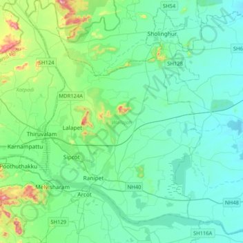
Name: Wallajah topographic map, elevation, terrain.

Location: Wallajah, Ranipet District, Tamil Nadu, India (12.84540 79.18821 13.15825 79.47424)

Average elevation: 179 m

Minimum elevation: 106 m

Maximum elevation: 547 m

Other topographic maps

Click on a map to view its topography, its elevation and its terrain.

Ranipet

India > Tamil Nadu > Wallajah

Average elevation: 172 m

KIlminnal

India > Tamil Nadu > Wallajah

Average elevation: 194 m

Chennasamudram

India > Tamil Nadu > Wallajah

Average elevation: 152 m

Nellikuppam

India > Tamil Nadu > Wallajah

Average elevation: 208 m

Karai

India > Tamil Nadu > Wallajah

Average elevation: 178 m

Ponnai

India > Tamil Nadu > Wallajah

Average elevation: 242 m

Agravaram

India > Tamil Nadu > Wallajah

Average elevation: 196 m

Gear up for your next adventure:

🥾Hiking Boots - Sturdy boots providing ankle support and traction on rugged trails
🧢Sun Protection Cap - Breathable cap to protect from sun exposure
🧤Rechargeable Heated Gloves - Extreme warmth for Canadian winter expeditions
🧦Crew Hiking Socks - Comfortable socks for long-distance hikes
🧳Compression Sacks - Maximize space in your backpack by shrinking gear

As an Amazon Associate, this site earns from qualifying purchases at no extra cost to you.