Geolocate

Ranipet topographic map

Click on the map to display elevation.

About this map

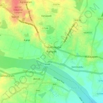
Name: Ranipet topographic map, elevation, terrain.

Location: Ranipet, Wallajah, Ranipet District, Tamil Nadu, 632401, India (12.88925 79.29217 12.96925 79.37217)

Average elevation: 172 m

Minimum elevation: 151 m

Maximum elevation: 203 m

Other topographic maps

Click on a map to view its topography, its elevation and its terrain.

Wallajah

India > Tamil Nadu > Wallajah

Average elevation: 179 m

Gear up for your next adventure:

🧣Evaporative Cooling Towel - Beat the heat during intense summer climbs
🦶Hiking Shoe Insoles - Added support for high arches and long days on feet
🥾Hiking Shorts - Breathable shorts suitable for summer hikes
🔋Solar Power Bank - Keep your GPS and devices charged during long outdoor trips
🥾Trekking Poles - Adjustable trekking poles to reduce knee stress and improve stability

As an Amazon Associate, this site earns from qualifying purchases at no extra cost to you.