Miller Peak topographic map
Click on the map to display elevation.
About this map
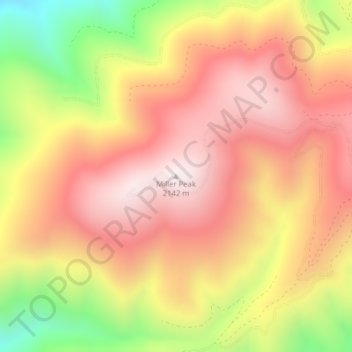
Name: Miller Peak topographic map, elevation, terrain.
Location: Miller Peak, Missoula County, Montana, United States (46.75737 -113.88738 46.75747 -113.88728)
Average elevation: 1,835 m
Minimum elevation: 1,378 m
Maximum elevation: 2,136 m
Other topographic maps
Click on a map to view its topography, its elevation and its terrain.
Missoula
United States > Montana > Missoula County
Missoula is located at the western edge of Montana, approximately 45 miles (70 km) from the Idaho border. The city is at an elevation of 3,209 feet (978 m) above sea level, with nearby Mount Sentinel and Mount Jumbo steeply rising to 5,158 feet (1,572 m) and 4,768 feet (1,453 m), respectively. According to the…
Average elevation: 1,173 m
Missoula
United States > Montana > Missoula County
Missoula is located at the western edge of Montana, approximately 45 miles (70 km) from the Idaho border. The city is at an elevation of 3,209 feet (978 m) above sea level, with nearby Mount Sentinel and Mount Jumbo steeply rising to 5,158 feet (1,572 m) and 4,768 feet (1,453 m), respectively. According to the…
Average elevation: 1,173 m

Missoula
United States > Montana > Missoula County
Missoula is located at the western edge of Montana, approximately 45 miles (70 km) from the Idaho border. The city is at an elevation of 3,209 feet (978 m) above sea level, with nearby Mount Sentinel and Mount Jumbo steeply rising to 5,158 feet (1,572 m) and 4,768 feet (1,453 m), respectively. According to the…
Average elevation: 1,173 m
Missoula
United States > Montana > Missoula County
Missoula is located at the western edge of Montana, less than 25 miles (40 km) from the Idaho border as the crow flies. By highway it is 117 miles (188 km) south of Kalispell, 118 miles (190 km) northwest of Butte and 165 miles (266 km) southeast of Coeur d'Alene, Idaho. The city is at an elevation of 3,209…
Average elevation: 1,173 m
Missoula
United States > Montana > Missoula County
Missoula is located at the western edge of Montana, less than 25 miles (40 km) from the Idaho border as the crow flies. By highway it is 117 miles (188 km) south of Kalispell, 118 miles (190 km) northwest of Butte and 165 miles (266 km) southeast of Coeur d'Alene, Idaho. The city is at an elevation of 3,209…
Average elevation: 1,173 m