Geolocate

Lolo topographic map

Click on the map to display elevation.

About this map

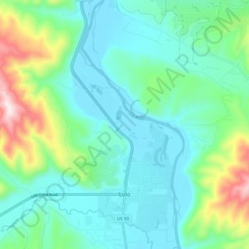
Name: Lolo topographic map, elevation, terrain.

Location: Lolo, Missoula County, Montana, United States (46.74265 -114.15588 46.80781 -114.05969)

Average elevation: 1,077 m

Minimum elevation: 951 m

Maximum elevation: 1,489 m

Gear up for your next adventure:

🌬️Windproof Camp Stove - Efficient cooking even on exposed mountain peaks
💧Collapsible Water Bottle - Space-saving water bottle for outdoor activities
🥾Hiking Gaiters - Protect legs and shoes from mud, snow, and debris
🧰Survival Kit - Essential gear for emergencies in the wilderness
💡Compact LED Flashlight - Powerful and portable flashlight for outdoor use

As an Amazon Associate, this site earns from qualifying purchases at no extra cost to you.