Geolocate

Frenchtown topographic map

Click on the map to display elevation.

About this map

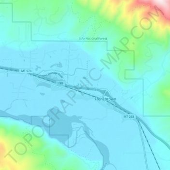
Name: Frenchtown topographic map, elevation, terrain.

Location: Frenchtown, Missoula County, Montana, United States (47.00406 -114.29376 47.03663 -114.19724)

Average elevation: 1,019 m

Minimum elevation: 915 m

Maximum elevation: 1,713 m

Other topographic maps

Click on a map to view its topography, its elevation and its terrain.

Lolo Hot Springs

United States > Montana > Missoula County

Average elevation: 1,377 m

Pinegrove

United States > Montana > Missoula County > East Missoula

Average elevation: 1,155 m

Huston

United States > Montana > Missoula County

Average elevation: 2,321 m

Huson

United States > Montana > Missoula County

Average elevation: 958 m

Huston

United States > Montana > Missoula County

Average elevation: 2,321 m

Miller Peak

United States > Montana > Missoula County

Average elevation: 1,835 m

Huston

United States > Montana > Missoula County

Average elevation: 2,321 m

Riata Park

United States > Montana > Missoula County > Missoula

Average elevation: 961 m

Huston

United States > Montana > Missoula County

Average elevation: 2,321 m

Gear up for your next adventure:

🧢Beanie Hat - Keep your head warm in cold weather
🌬️Windproof Camp Stove - Efficient cooking even on exposed mountain peaks
🧥Ultralight Puffy Jacket - Maximum warmth that packs down to the size of an orange
📷Outdoor Action Camera - Capture high-elevation views and rugged adventures
🥾Hiking Leggings - Comfortable leggings for outdoor activities

As an Amazon Associate, this site earns from qualifying purchases at no extra cost to you.