Geolocate

Clinton topographic map

Click on the map to display elevation.

About this map

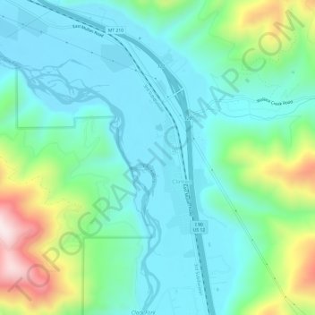
Name: Clinton topographic map, elevation, terrain.

Location: Clinton, Missoula County, Montana, United States (46.75143 -113.74870 46.79267 -113.70758)

Average elevation: 1,180 m

Minimum elevation: 1,037 m

Maximum elevation: 1,631 m

Other topographic maps

Click on a map to view its topography, its elevation and its terrain.

Lolo Hot Springs

United States > Montana > Missoula County

Average elevation: 1,377 m

Pinegrove

United States > Montana > Missoula County > East Missoula

Average elevation: 1,155 m

Huston

United States > Montana > Missoula County

Average elevation: 2,321 m

Huson

United States > Montana > Missoula County

Average elevation: 958 m

Huston

United States > Montana > Missoula County

Average elevation: 2,321 m

Miller Peak

United States > Montana > Missoula County

Average elevation: 1,835 m

Huston

United States > Montana > Missoula County

Average elevation: 2,321 m

Riata Park

United States > Montana > Missoula County > Missoula

Average elevation: 961 m

Huston

United States > Montana > Missoula County

Average elevation: 2,321 m

Gear up for your next adventure:

🛶Waterproof Dry Bags - Keep electronics and clothes dry during river crossings
💡Compact LED Flashlight - Powerful and portable flashlight for outdoor use
🪑Insulated Seat Pad - Protect your seat from cold rocks and wet logs
🔭Compact Monocular - One-handed bird watching and trail spotting
🌡️Emergency Mylar Blankets - Compact thermal protection for unexpected nights outdoors

As an Amazon Associate, this site earns from qualifying purchases at no extra cost to you.