Geolocate

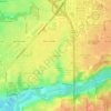
Madison County topographic map

Click on the map to display elevation.

About this map

Name: Madison County topographic map, elevation, terrain.

Location: Madison County, Indiana, United States (39.94364 -85.86302 40.37968 -85.57539)

Average elevation: 270 m

Minimum elevation: 230 m

Maximum elevation: 336 m

Other topographic maps

Click on a map to view its topography, its elevation and its terrain.

Mansfield

United States > Indiana > Parke County

Average elevation: 196 m

Deer Creek

United States > Indiana > Carroll County > Delphi

Average elevation: 188 m

Klondyke

United States > Indiana > Parke County

Average elevation: 168 m

Perth

United States > Indiana > Clay County

Average elevation: 193 m

Byron

United States > Indiana > Parke County

Average elevation: 226 m

Pleasant

United States > Indiana > Switzerland County

Average elevation: 282 m

Groomsville

United States > Indiana > Tipton County > Groomsville

Average elevation: 275 m

Gear up for your next adventure:

🧭GPS Handheld Device - Reliable GPS navigation for outdoor adventures
🧢Hiking Hat - Sun-protective and breathable hats for long treks
🛏️Sleeping Bag - Warm and compact sleeping bags for outdoor camping
❄️Traction Ice Cleats - Slip-on spikes for icy trails and winter hiking
🧢Sun Protection Cap - Breathable cap to protect from sun exposure

As an Amazon Associate, this site earns from qualifying purchases at no extra cost to you.