
Make a donation
Gear up for your next adventure:
As an Amazon Associate, this site earns from qualifying purchases at no extra cost to you.
Altbüron topographic map
Click on the map to display elevation.
Make a donation
Gear up for your next adventure:
As an Amazon Associate, this site earns from qualifying purchases at no extra cost to you.
Altbüron
Die Gemeinde liegt im Nordwesten des Luzerner Hinterlands und grenzt am Rotbach im Westen der Gemeinde an die Gemeinde Melchnau im Kanton Bern. Der höchste Punkt der Gemeinde ist mit 725 m ü. M. die Schartenhöhe beim Weiler Bellevue nordöstlich des Dorfes. Im Grünbach im Westen der Gemeinde Altbüron liegt der tiefste Punkt mit 495 m ü. M., während das Dorf selber auf rund 545 m ü. M. liegt. Altbüron besteht nebst dem Dorf aus zahlreichen Streusiedlungen und Einzelgehöften. 2015/16 werden 59,9 % des Gemeindegebietes von 673 ha landwirtschaftlich genutzt. Weitere 29,1 % sind Wald und Gehölz und bloss 10,8 % Siedlungsfläche.
Make a donation
Gear up for your next adventure:
As an Amazon Associate, this site earns from qualifying purchases at no extra cost to you.
About this map
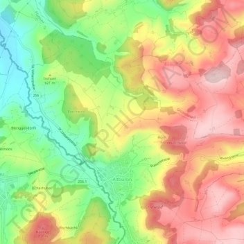
Name: Altbüron topographic map, elevation, terrain.
Location: Altbüron, Luzern, 6147, Schweiz (47.17616 7.85939 47.20558 7.91775)
Average elevation: 617 m
Minimum elevation: 484 m
Maximum elevation: 739 m
Make a donation
Gear up for your next adventure:
As an Amazon Associate, this site earns from qualifying purchases at no extra cost to you.
Other topographic maps
Click on a map to view its topography, its elevation and its terrain.
Make a donation
Gear up for your next adventure:
As an Amazon Associate, this site earns from qualifying purchases at no extra cost to you.
Marbach LU
Schweiz > Luzern > Escholzmatt-Marbach
Durch die zerklüftete Landschaft bedingt, gibt es zahlreiche Ortsteile, Häusergruppen und Einzelgehöfte. Das Dorf Marbach liegt fünf Kilometer südlich von Wiggen an der Schallenbergstrasse (Luzern-Wiggen-Thun). Mittlerweile mit dem Dorf verwachsen sind die Weiler Moos (südwestlich) und Erlenmoos…
Average elevation: 1,056 m
Make a donation
Gear up for your next adventure:
As an Amazon Associate, this site earns from qualifying purchases at no extra cost to you.
Make a donation
Gear up for your next adventure:
As an Amazon Associate, this site earns from qualifying purchases at no extra cost to you.
Make a donation
Gear up for your next adventure:
As an Amazon Associate, this site earns from qualifying purchases at no extra cost to you.
Make a donation
Gear up for your next adventure:
As an Amazon Associate, this site earns from qualifying purchases at no extra cost to you.
Make a donation
Gear up for your next adventure:
As an Amazon Associate, this site earns from qualifying purchases at no extra cost to you.
Make a donation
Gear up for your next adventure:
As an Amazon Associate, this site earns from qualifying purchases at no extra cost to you.
Make a donation
Gear up for your next adventure:
As an Amazon Associate, this site earns from qualifying purchases at no extra cost to you.
Make a donation
Gear up for your next adventure:
As an Amazon Associate, this site earns from qualifying purchases at no extra cost to you.
Make a donation
Gear up for your next adventure:
As an Amazon Associate, this site earns from qualifying purchases at no extra cost to you.
Make a donation
Gear up for your next adventure:
As an Amazon Associate, this site earns from qualifying purchases at no extra cost to you.