
Dundee topographic map
Click on the map to display elevation.
About this map
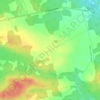
Name: Dundee topographic map, elevation, terrain.
Location: Dundee, Kings County, Prince Edward Island, Canada (46.39251 -62.77789 46.41251 -62.75789)
Average elevation: 24 m
Minimum elevation: 0 m
Maximum elevation: 50 m
Kings County trails, hiking, mountain biking, running and outdoor activities
Other topographic maps
Click on a map to view its topography, its elevation and its terrain.
Rural Municipality of Murray River
Canada > Prince Edward Island > Kings County
Average elevation: 20 m
Prince Edward Island National Park
Canada > Prince Edward Island > Kings County > Greenwich
Average elevation: 2 m
Rural Municipality of Murray River
Canada > Prince Edward Island > Kings County
Average elevation: 20 m