Geolocate

DeGros Marsh topographic map

Click on the map to display elevation.

About this map

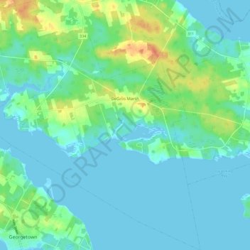
Name: DeGros Marsh topographic map, elevation, terrain.

Location: DeGros Marsh, Town of Three Rivers, Kings County, Prince Edward Island, Canada (46.18009 -62.54969 46.25941 -62.45016)

Average elevation: 10 m

Minimum elevation: -1 m

Maximum elevation: 41 m

Kings County trails, hiking, mountain biking, running and outdoor activities

Other topographic maps

Click on a map to view its topography, its elevation and its terrain.

Dundee

Canada > Prince Edward Island > Kings County

Average elevation: 24 m

Gear up for your next adventure:

Camping Essentials - All-in-one gear for a comfortable camping trip
Lightweight Camping Tent - Portable shelter optimized for Canadian backcountry camping
Camping Tent - Weather-resistant tents suitable for 2 to 6 people
👟Leg Gaiters - Keep debris, mud, and snow out of your boots
👟Sport Hiking Sandals - Breathable footwear for water crossings and camp rest

As an Amazon Associate, this site earns from qualifying purchases at no extra cost to you.