
Osogbo topographic map
Interactive map
Click on the map to display elevation.
About this map
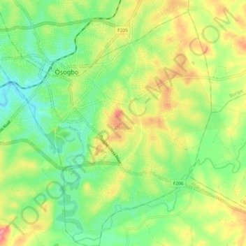
Name: Osogbo topographic map, elevation, terrain.
Location: Osogbo, Osun State, 230261, Nigeria (7.71429 4.52451 7.80540 4.60799)
Average elevation: 328 m
Minimum elevation: 285 m
Maximum elevation: 390 m
Other topographic maps
Click on a map to view its topography, its elevation and its terrain.
Ifewara
Nigeria > Osun State > Atakunmosa West
Ifewara, Atakunmosa West, Osun State, Nigeria
Average elevation: 338 m
Ilesa
Nigeria > Osun State > Ilesha West
Ilesa, Ilesha West, Osun State, Nigeria
Average elevation: 354 m