
Maule Region topographic map
Click on the map to display elevation.
About this map
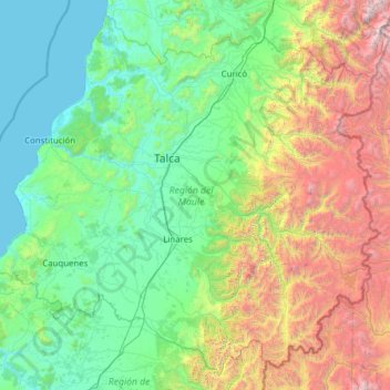
Name: Maule Region topographic map, elevation, terrain.
Location: Maule Region, Chile (-36.54362 -72.78638 -34.68453 -70.30761)
Average elevation: 908 m
Minimum elevation: 0 m
Maximum elevation: 4,855 m
Other topographic maps
Click on a map to view its topography, its elevation and its terrain.
Santiago
Chile > Santiago Metropolitan Region > Provincia de Santiago
The city lies in the center of the Santiago Basin, a large bowl-shaped valley consisting of broad and fertile lands surrounded by mountains. The city has a varying elevation, gradually increasing from 400 m (1,312 ft) in the western areas to more than 700 m (2,297 ft) in the eastern areas. Santiago's…
Average elevation: 722 m
Punta Arenas
Chile > Magallanes and Chilean Antarctica Region > Provincia de Magallanes
Average elevation: 122 m
Atacama Desert
Chile > Antofagasta Region > Provincia de Antofagasta > Antofagasta
The Coastal Cliff of northern Chile west of the Chilean Coast Range is the main topographical feature of the coast. The geomorphology of the Atacama Desert has been characterized as a low-relief bench "similar to a giant uplifted terrace" by Armijo and co-workers. The intermediate depression (or Central…
Average elevation: 1,961 m
Cascada de Ventisquero Colgante
Chile > Aysen del General Carlos Ibanez del Campo Region > Provincia de Aysén > Cisnes
Average elevation: 1,022 m
Santiago
Chile > Santiago Metropolitan Region > Provincia de Santiago
The city lies in the center of the Santiago Basin, a large bowl-shaped valley consisting of broad and fertile lands surrounded by mountains. The city has a varying elevation, gradually increasing from 400 m (1,312 ft) in the western areas to more than 700 m (2,297 ft) in the eastern areas. Santiago's…
Average elevation: 722 m
Escuela Agrícola Vista Hermosa
Chile > Los Lagos Region > Provincia de Osorno > Río Negro
Average elevation: 78 m
Melinka
Chile > Aysen del General Carlos Ibanez del Campo Region > Provincia de Aysén > Guaitecas
Average elevation: 26 m
Atacama Desert
Chile > Antofagasta Region > Provincia de Antofagasta > Antofagasta
The Coastal Cliff of northern Chile west of the Chilean Coast Range is the main topographical feature of the coast. The geomorphology of the Atacama Desert has been characterized as a low-relief bench "similar to a giant uplifted terrace" by Armijo and co-workers. The intermediate depression (or Central…
Average elevation: 1,961 m
Tupungato
Chile > Santiago Metropolitan Region > Provincia de Cordillera > San José de Maipo
Tupungato Department, an important Argentine wine-producing region in Mendoza province, is named for the volcano. Recent Chilean mapping indicates it has a summit elevation of 6635 m.
Average elevation: 6,002 m
Farellones
Chile > Santiago Metropolitan Region > Provincia de Santiago
Located in the commune of Lo Barnechea, 36 km from Santiago at an altitude of 2,340 meters above sea level (7,874 feet), Farellones has a health centre, a school, and about 200 houses. The houses and cabins are made of wood, giving the village its characteristic look.
Average elevation: 2,243 m
El Curato Oriente
Chile > Santiago Metropolitan Region > Provincia de Talagante
Average elevation: 438 m
Cerro Torre
Chile > Magallanes and Chilean Antarctica Region > Provincia de Última Esperanza
Average elevation: 1,916 m
Valle del Aconcagua
Chile > Valparaiso Region > Provincia de Quillota > Hijuelas > La Sombra
Average elevation: 349 m
Ojos del Salado
Chile > Atacama Region > Provincia de Copiapó > Copiapó
Nevado Ojos del Salado is a dormant complex volcano in the Andes on the Argentina–Chile border. It is the highest volcano on Earth and the highest peak in Chile. The upper reaches of Ojos del Salado consist of several overlapping lava domes, lava flows and volcanic craters, with sparse ice cover. The complex…
Average elevation: 6,446 m
Bahía Inglesa
Chile > Atacama Region > Provincia de Copiapó > Caldera
Bahia Inglesa ("English Bay") is a locality located near the port of Caldera in Atacama Region, Chile. It is situated at an average elevation of 10 meters above the sea level. As of 2017, it had a population of 535.
Average elevation: 10 m
Santiago
Chile > Santiago Metropolitan Region > Provincia de Santiago
The city lies in the center of the Santiago Basin, a large bowl-shaped valley consisting of broad and fertile lands surrounded by mountains. The city has a varying elevation, gradually increasing from 400 m (1,312 ft) in the western areas to more than 700 m (2,297 ft) in the eastern areas. Santiago's…
Average elevation: 722 m
Carretera Austral
Chile > Aysen del General Carlos Ibanez del Campo Region > Provincia de General Carrera > Río Ibáñez
Average elevation: 414 m
Cerro Torre
Chile > Magallanes and Chilean Antarctica Region > Provincia de Última Esperanza > Puerto Natales
Average elevation: 1,916 m
Puerto Williams
Chile > Magallanes and Chilean Antarctica Region > Provincia de la Antártica Chilena > Cape Horn
The climate of Puerto Williams is a temperate subpolar oceanic climate (Cfc) bordering closely on a tundra climate (ET) according to the Köppen climate classification. The summers are short and cool while the winters are long, wet, but moderate. Rainfall is around 512.3 mm (20 in) a year and temperatures are…
Average elevation: 151 m
Santiago
Chile > Santiago Metropolitan Region > Provincia de Santiago
The city lies in the center of the Santiago Basin, a large bowl-shaped valley consisting of broad and fertile lands surrounded by mountains. The city has a varying elevation, gradually increasing from 400 meters (1,300 feet) in the western areas to more than 700 m (2,297 ft) in the eastern areas. Santiago's…
Average elevation: 722 m
Zona Austral
Chile > Region of Magallanes and Chilean Antarctica > Provincia de Última Esperanza > Puerto Natales
In the far south (Chile Austral), which extends from Valdivia through the Chacao Channel to Cape Horn, the Andes and the South Pacific meet. This district of the country is mountainous, heavily forested and inhospitable. The deeply indented coastline is filled with islands which preserve the general outline of…
Average elevation: 768 m
Cerro Ballena
Chile > Magallanes and Chilean Antarctica Region > Provincia de Última Esperanza
Average elevation: 400 m
Puyuhuapi
Chile > Aysen del General Carlos Ibanez del Campo Region > Provincia de Aysén > Cisnes
Average elevation: 229 m
Humedal Desembocadura del Río Copiapó
Chile > Atacama Region > Provincia de Copiapó > Caldera
Average elevation: 31 m
Peldehue
Chile > Santiago Metropolitan Region > Provincia de Chacabuco > Colina
Average elevation: 743 m
Isla Florencia
Chile > Aysen del General Carlos Ibanez del Campo Region > Provincia de Aysén > Cisnes
Average elevation: 13 m
Isla Carmen
Chile > Aysen del General Carlos Ibanez del Campo Region > Provincia de Aysén > Puerto Aysén
Average elevation: 22 m
Santuario de la Naturaleza y RENAMU Humedal Desembocadura Río Lluta
Chile > Arica and Parinacota Region > Provincia de Arica > Arica > Villa Frontera > Las Machas
Average elevation: 10 m
Mirador Cóndor
Chile > Magallanes and Chilean Antarctica Region > Provincia de Última Esperanza > Torres del Paine
Average elevation: 140 m
Puerto Williams
Chile > Magallanes and Chilean Antarctica Region > Provincia de la Antártica Chilena > Cape Horn
The climate of Puerto Williams is a temperate subpolar oceanic climate (Cfc) bordering closely on a tundra climate (ET) according to the Köppen climate classification. The summers are short and cool while the winters are long, wet, but moderate. Rainfall is around 512.3 mm (20 in) a year and temperatures are…
Average elevation: 151 m
Agua de la Gloria
Chile > Biobío Region > Provincia de Concepción > Concepcion > El Pino
Average elevation: 94 m
Laguna de los Cisnes
Chile > Magallanes and Chilean Antarctica Region > Provincia de Tierra del Fuego > Porvenir
Average elevation: 31 m
Santiago
Chile > Santiago Metropolitan Region > Provincia de Santiago
The city lies in the center of the Santiago Basin, a large bowl-shaped valley consisting of broad and fertile lands surrounded by mountains. The city has a varying elevation, gradually increasing from 400 m (1,312 ft) in the western areas to more than 700 m (2,297 ft) in the eastern areas. Santiago's…
Average elevation: 724 m
Cerro Las Tórtolas
Chile > Coquimbo Region > Provincia de Elqui > Vicuña
Cerro Las Tórtolas is a peak at the border of Argentina and Chile with an elevation of 6,145 metres (20,161 ft) metres and located at the Central Andes. It is on the border of the Argentinean province of San Juan and Chilean province of Elqui. Its slopes are within the administrative boundaries of Argentinean…
Average elevation: 5,610 m
Peteroa
Chile > Maule Region > Provincia de Curicó > Sagrada Familia > Santa Ana
Average elevation: 139 m
Yendegaia
Chile > Magallanes and Chilean Antarctica Region > Provincia de la Antártica Chilena > Cape Horn
Average elevation: 91 m
Puerto Guadal
Chile > Aysen del General Carlos Ibanez del Campo Region > Provincia de General Carrera > Chile Chico
Average elevation: 347 m
Camar
Chile > Antofagasta Region > Provincia de El Loa > San Pedro de Atacama
Average elevation: 2,722 m
Lake Pehoé
Chile > Region of Magallanes and Chilean Antarctica > Provincia de Última Esperanza > Torres del Paine
Average elevation: 69 m
Zona Sur
Chile > Los Ríos Region > Provincia de Ranco > Río Bueno
Although many lakes can be found in the Andean and coastal regions of central Chile, the south (Sur de Chile) has the country's most lakes. Southern Chile stretches from below the Río Bío-Bío at about 37° south latitude to below Isla de Chiloé at about 43.4° south latitude. In this lake district of…
Average elevation: 399 m
Punta Roa
Chile > Valparaiso Region > Easter Island Province > Easter Island > Hanga Roa
Average elevation: 11 m
Valle Nevado
Chile > Santiago Metropolitan Region > Provincia de Santiago > Lo Barnechea
Due to its elevation, Valle Nevado has a subalpine climate (Dfc, according to the Köppen climate classification, bordering on Dfb and ET), with drier summers and humid winters, with an average annual precipitation of 1,042 mm (41 in). Summers are chilly and dry, while winters are cold and snowy.
Average elevation: 2,811 m
Puerto Natales
Chile > Magallanes and Chilean Antarctica Region > Provincia de Última Esperanza
Average elevation: 141 m
Parque Tricao
Chile > Valparaiso Region > Provincia de San Antonio > Santo Domingo
Average elevation: 76 m
Canal de Relave Codelco División El Teniente
Chile > Provincia de Cachapoal > Requínoa
Average elevation: 629 m
Zona Central
Chile > Maule Region > Provincia de Curicó > Teno
The topography of central Chile includes a coastal range of mountains running parallel to the Andes. Lying between the two mountain ranges is the so-called Central Valley, which contains some of the richest agricultural land in the country, especially in its northern portion. The area just north and south of…
Average elevation: 1,121 m
Puerto Natales
Chile > Magallanes and Chilean Antarctica Region > Provincia de Última Esperanza
Average elevation: 141 m
Cerro Arco
Chile > Aysen del General Carlos Ibanez del Campo Region > Provincia de Capitán Prat > Cochrane
Average elevation: 2,456 m
Cape Horn
Chile > Magallanes and Chilean Antarctica Region > Provincia de la Antártica Chilena > Cape Horn
Average elevation: 49 m
Ojos del Salado
Chile > Atacama Region > Provincia de Copiapó > Copiapó
Nevado Ojos del Salado is a dormant complex volcano in the Andes on the Argentina–Chile border. It is the highest volcano on Earth and the highest peak in Chile. The upper reaches of Ojos del Salado consist of several overlapping lava domes, lava flows and volcanic craters, with sparse ice cover. The complex…
Average elevation: 6,446 m
Socaire
Chile > Antofagasta Region > Provincia de El Loa > San Pedro de Atacama
Average elevation: 3,291 m
El Cobre
Chile > Valparaiso Region > Provincia de San Felipe de Aconcagua > Catemu
Average elevation: 547 m
Laguna Lejía
Chile > Antofagasta Region > Provincia de El Loa > San Pedro de Atacama
Lejía Lake is a circular, shallow lake at an elevation of 4,325 metres (14,190 ft) with a surface area of 1.9 square kilometres (0.73 sq mi) or 2 square kilometres (0.77 sq mi). It is a polymictic lake which freezes over occasionally and whose waters are turned over quickly, mainly through evaporation. Winds…
Average elevation: 4,341 m
Clear water
Chile > Aysen del General Carlos Ibanez del Campo Region > Provincia de Capitán Prat > O’Higgins
Average elevation: 399 m