
Make a donation
Gear up for your next adventure:
As an Amazon Associate, this site earns from qualifying purchases at no extra cost to you.
Mifflin County topographic map
Click on the map to display elevation.
Make a donation
Gear up for your next adventure:
As an Amazon Associate, this site earns from qualifying purchases at no extra cost to you.
About this map
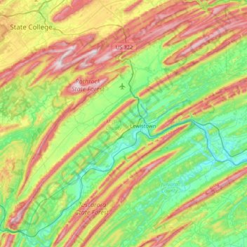
Name: Mifflin County topographic map, elevation, terrain.
Location: Mifflin County, Pennsylvania, United States (40.36034 -77.91393 40.84694 -77.28805)
Average elevation: 337 m
Minimum elevation: 126 m
Maximum elevation: 735 m
Make a donation
Gear up for your next adventure:
As an Amazon Associate, this site earns from qualifying purchases at no extra cost to you.
Other topographic maps
Click on a map to view its topography, its elevation and its terrain.
East Texas
United States > Pennsylvania > Lehigh County > Lower Macungie Township
Average elevation: 126 m
Donegal Lake
United States > Pennsylvania > Westmoreland County > Donegal Township
Average elevation: 493 m
Orefield
United States > Pennsylvania > Lehigh County > North Whitehall Township
Average elevation: 141 m
Make a donation
Gear up for your next adventure:
As an Amazon Associate, this site earns from qualifying purchases at no extra cost to you.
Dingmans Ferry
United States > Pennsylvania > Pike County > Delaware Township
Average elevation: 192 m
Make a donation
Gear up for your next adventure:
As an Amazon Associate, this site earns from qualifying purchases at no extra cost to you.
Middlebury Center
United States > Pennsylvania > Tioga County > Middlebury Township
Average elevation: 462 m
Woxall
United States > Pennsylvania > Montgomery County > Upper Salford Township
Average elevation: 98 m
Make a donation
Gear up for your next adventure:
As an Amazon Associate, this site earns from qualifying purchases at no extra cost to you.
Centreville
United States > Pennsylvania > Lehigh County > Lower Macungie Township
Average elevation: 144 m
Bass Lake
United States > Pennsylvania > York County > Newberry Township > Valley Green
Average elevation: 143 m
Croydon Heights
United States > Pennsylvania > Bucks County > Bristol Township > Croydon
Average elevation: 10 m
Make a donation
Gear up for your next adventure:
As an Amazon Associate, this site earns from qualifying purchases at no extra cost to you.
Fitzwatertown
United States > Pennsylvania > Montgomery County > Upper Dublin Township
Average elevation: 86 m
Starview
United States > Pennsylvania > York County > East Manchester Township
Average elevation: 155 m
North Towanda
United States > Pennsylvania > Bradford County > North Towanda Township
Average elevation: 286 m
Make a donation
Gear up for your next adventure:
As an Amazon Associate, this site earns from qualifying purchases at no extra cost to you.
Albrightsville
United States > Pennsylvania > Carbon County > Kidder Township
Average elevation: 498 m
Make a donation
Gear up for your next adventure:
As an Amazon Associate, this site earns from qualifying purchases at no extra cost to you.
Make a donation
Gear up for your next adventure:
As an Amazon Associate, this site earns from qualifying purchases at no extra cost to you.
Freemont
United States > Pennsylvania > Chester County > West Nottingham Township
Average elevation: 115 m
Sturgeon
United States > Pennsylvania > Allegheny County > North Fayette Township
Average elevation: 334 m
Glade Mills
United States > Pennsylvania > Butler County > Middlesex Township
Average elevation: 359 m
Make a donation
Gear up for your next adventure:
As an Amazon Associate, this site earns from qualifying purchases at no extra cost to you.
Knickerbocker
United States > Pennsylvania > Chester County > Willistown Township
Average elevation: 127 m
Carlisle Springs
United States > Pennsylvania > Cumberland County > Middlesex Township
Average elevation: 182 m
Vance
United States > Pennsylvania > Washington County > South Strabane Township
Average elevation: 371 m
Sagamore Estates
United States > Pennsylvania > Pike County > Shohola Township
Average elevation: 412 m
Make a donation
Gear up for your next adventure:
As an Amazon Associate, this site earns from qualifying purchases at no extra cost to you.
Evansburg State Park
United States > Pennsylvania > Montgomery County > Worcester Township > Cedars
Average elevation: 70 m
Cross Fork
United States > Pennsylvania > Potter County > Stewardson Township
Average elevation: 467 m
Make a donation
Gear up for your next adventure:
As an Amazon Associate, this site earns from qualifying purchases at no extra cost to you.
Ithan
United States > Pennsylvania > Delaware County > Radnor Township > Saint Davids
Average elevation: 116 m
Drumore Center
United States > Pennsylvania > Lancaster County > Drumore Township
Average elevation: 175 m
Strickhousers
United States > Pennsylvania > York County > North Codorus Township
Average elevation: 205 m
Make a donation
Gear up for your next adventure:
As an Amazon Associate, this site earns from qualifying purchases at no extra cost to you.
Pocono Lake
United States > Pennsylvania > Monroe County > Tobyhanna Township
Average elevation: 543 m
Make a donation
Gear up for your next adventure:
As an Amazon Associate, this site earns from qualifying purchases at no extra cost to you.
Intercourse
United States > Pennsylvania > Lancaster County > Leacock Township
Average elevation: 127 m
Make a donation
Gear up for your next adventure:
As an Amazon Associate, this site earns from qualifying purchases at no extra cost to you.
East Waterford
United States > Pennsylvania > Juniata County > Tuscarora Township
Average elevation: 257 m
Make a donation
Gear up for your next adventure:
As an Amazon Associate, this site earns from qualifying purchases at no extra cost to you.
Snyders
United States > Pennsylvania > Schuylkill County > West Penn Township
Average elevation: 242 m
La Mott Community Center & Playground
United States > Pennsylvania > Montgomery County > Cheltenham Township > Lamott
Average elevation: 77 m
Coraopolis Heights
United States > Pennsylvania > Allegheny County > Findlay Township
Average elevation: 320 m
Make a donation
Gear up for your next adventure:
As an Amazon Associate, this site earns from qualifying purchases at no extra cost to you.
Central Highlands
United States > Pennsylvania > Allegheny County > Elizabeth Township
Average elevation: 327 m
Tyler State Park
United States > Pennsylvania > Bucks County > Northampton Township
Average elevation: 67 m
Make a donation
Gear up for your next adventure:
As an Amazon Associate, this site earns from qualifying purchases at no extra cost to you.
Make a donation
Gear up for your next adventure:
As an Amazon Associate, this site earns from qualifying purchases at no extra cost to you.
Stoverstown
United States > Pennsylvania > York County > North Codorus Township
Average elevation: 171 m
Illick's Mill Road Gateway
United States > Pennsylvania > Northampton County > Bethlehem
Average elevation: 105 m
Hopeland
United States > Pennsylvania > Lancaster County > Clay Township > Clay
Average elevation: 155 m
Springfield
United States > Pennsylvania > Bradford County > Springfield Township
Average elevation: 442 m
Make a donation
Gear up for your next adventure:
As an Amazon Associate, this site earns from qualifying purchases at no extra cost to you.
Gladwyne
United States > Pennsylvania > Montgomery County > Lower Merion Township
Average elevation: 92 m
Villanova
United States > Pennsylvania > Delaware County > Radnor Township > Radnor
Average elevation: 119 m
Morewood
United States > Pennsylvania > Westmoreland County > East Huntingdon Township
Average elevation: 357 m
Make a donation
Gear up for your next adventure:
As an Amazon Associate, this site earns from qualifying purchases at no extra cost to you.
Blue Mountain
United States > Pennsylvania > Schuylkill County > Washington Township
The ridge of Blue Mountain runs for 150 miles (240 km) through Pennsylvania, reaching an elevation of 2,270 feet (690 m) above sea level just north of the Pennsylvania Turnpike, near the borough of Newburg. Most of the ridgecrest, however, only reaches between 1,400 and 1,700 feet (430 and 520 m) in elevation.…
Average elevation: 226 m
Hanover Junction
United States > Pennsylvania > York County > North Codorus Township
Average elevation: 187 m
Make a donation
Gear up for your next adventure:
As an Amazon Associate, this site earns from qualifying purchases at no extra cost to you.
Stiefler Corner
United States > Pennsylvania > Bedford County > Kimmel Township
Average elevation: 520 m
Leather Corner Post
United States > Pennsylvania > Lehigh County > Lowhill Township
Average elevation: 178 m
Welsh Mountain Nature Preserve
United States > Pennsylvania > Lancaster County > East Earl Township
Average elevation: 294 m
Make a donation
Gear up for your next adventure:
As an Amazon Associate, this site earns from qualifying purchases at no extra cost to you.
East Springfield
United States > Pennsylvania > Erie County > Springfield Township
Average elevation: 229 m
Raven Rock Mountain
United States > Pennsylvania > Adams County > Liberty Township
Average elevation: 312 m
Plumsteadville
United States > Pennsylvania > Bucks County > Plumstead Township
Average elevation: 160 m
Spring Plains
United States > Pennsylvania > York County > Springettsbury Township
Average elevation: 151 m
Make a donation
Gear up for your next adventure:
As an Amazon Associate, this site earns from qualifying purchases at no extra cost to you.
Dresher
United States > Pennsylvania > Montgomery County > Upper Dublin Township
Average elevation: 82 m
Dingmans Ferry
United States > Pennsylvania > Pike County > Delaware Township
Average elevation: 192 m
Make a donation
Gear up for your next adventure:
As an Amazon Associate, this site earns from qualifying purchases at no extra cost to you.
Valley Forge
United States > Pennsylvania > Chester County > Schuylkill Township
Average elevation: 78 m
Make a donation
Gear up for your next adventure:
As an Amazon Associate, this site earns from qualifying purchases at no extra cost to you.
Crooked Creek Lake
United States > Pennsylvania > Armstrong County > Bethel Township
Average elevation: 288 m
East Passyunk Community Recreation Center
United States > Pennsylvania > Philadelphia County > Philadelphia
Average elevation: 9 m
Make a donation
Gear up for your next adventure:
As an Amazon Associate, this site earns from qualifying purchases at no extra cost to you.