Geolocate

Staton topographic map

Click on the map to display elevation.

About this map

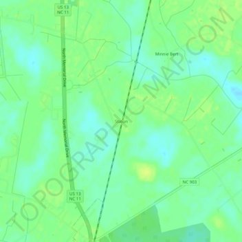
Name: Staton topographic map, elevation, terrain.

Location: Staton, Pitt County, North Carolina, United States (35.66877 -77.37469 35.70877 -77.33469)

Average elevation: 12 m

Minimum elevation: 4 m

Maximum elevation: 19 m

Other topographic maps

Click on a map to view its topography, its elevation and its terrain.

Greenville

United States > North Carolina > Pitt County

Average elevation: 16 m

Farmville

United States > North Carolina > Pitt County

Average elevation: 24 m

Simpson

United States > North Carolina > Pitt County

Average elevation: 18 m

Farmville

United States > North Carolina > Pitt County

Average elevation: 24 m

Gear up for your next adventure:

🧴Insect Repellent - Protect yourself from bugs during outdoor adventures
🦌Outdoor Trail Camera - Monitor wildlife activity near your favorite spots
🥾Durable Hiking Shoes - Long-lasting shoes for frequent hiking
Lightweight Backpacking Tent - Compact tent for efficient hiking trips
Camping Groundsheet - Protect your tent from moisture and dirt

As an Amazon Associate, this site earns from qualifying purchases at no extra cost to you.