

Valles Caldera topographic map
Click on the map to display elevation.
Valles Caldera
On July 25, 2025, the Valles Caldera National Preserve opened their new Volcano Discovery Center. Superintendent Jorge Silva-Bañuelos cut the opening ribbon. Visitors can interact with a 12-foot topographic relief map at the center of an exhibit designed by local New Mexico company, Ideum. Guests can also explore detailed park maps, read FAQ's, check real-time alerts, access a live seismograph feed, digital docents, and review stories collected from the four themes: Geology, Ecology, Cultural History, and Scientific on interactive touchscreens.
About this map
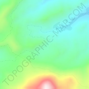
Name: Valles Caldera topographic map, elevation, terrain.
Location: Valles Caldera, Sandoval County, New Mexico, United States (35.89997 -106.55064 35.90007 -106.55054)
Average elevation: 2,899 m
Minimum elevation: 2,730 m
Maximum elevation: 3,317 m
Other topographic maps
Click on a map to view its topography, its elevation and its terrain.
Rio Rancho
United States > New Mexico > Sandoval County
Rio Rancho is in an arid climate due to its location in the rain shadow of the Sandia Mountains to the east and the Continental Divide to the west. Rio Rancho receives 8.90 inches of precipitation annually on average. The western portion of the city receives slightly more rain and snowfall due to its higher…
Average elevation: 1,672 m



Rio Rancho
United States > New Mexico > Sandoval County
Rio Rancho is in an arid climate due to its location in the rain shadow of the Sandia Mountains to the east and the Continental Divide to the west. Rio Rancho receives 8.90 inches (226 mm) of precipitation annually on average. The western portion of the city receives slightly more rain and snowfall due to its…
Average elevation: 1,672 m
Rio Rancho
United States > New Mexico > Sandoval County
Rio Rancho is in an arid climate due to its location in the rain shadow of the Sandia Mountains to the east and the Continental Divide to the west. Rio Rancho receives 8.90 inches of precipitation annually on average. The western portion of the city receives slightly more rain and snowfall due to its higher…
Average elevation: 1,672 m