Geolocate

Valles Caldera topographic map

Click on the map to display elevation.

About this map

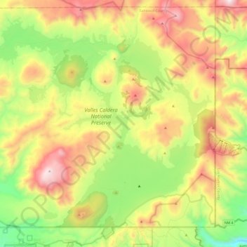
Name: Valles Caldera topographic map, elevation, terrain.

Location: Valles Caldera, Sandoval County, New Mexico, United States (35.82462 -106.64280 35.99318 -106.40282)

Average elevation: 2,772 m

Minimum elevation: 2,213 m

Maximum elevation: 3,480 m

Other topographic maps

Click on a map to view its topography, its elevation and its terrain.

Seven Springs

United States > New Mexico > Sandoval County

Average elevation: 2,538 m

Placitas

United States > New Mexico > Sandoval County

Average elevation: 1,864 m

Placitas

United States > New Mexico > Sandoval County

Average elevation: 1,864 m

La Cueva

United States > New Mexico > Sandoval County

Average elevation: 2,470 m

Redondo Peak

United States > New Mexico > Sandoval County

Average elevation: 3,193 m

San Luis

United States > New Mexico > Sandoval County

Average elevation: 1,919 m

Cabezon

United States > New Mexico > Sandoval County

Average elevation: 1,888 m

Gear up for your next adventure:

💧Reusable Water Bottle - Durable water bottles for hydration on trails
🥾Hiking Boots - Sturdy boots providing ankle support and traction on rugged trails
🧦Outdoor Socks - Durable socks designed for hiking and outdoor sports
🧴Waterproofing Spray - Restore the DWR coating on jackets and tents
🌬️Windproof Camp Stove - Efficient cooking even on exposed mountain peaks

As an Amazon Associate, this site earns from qualifying purchases at no extra cost to you.