Geolocate

Regina topographic map

Click on the map to display elevation.

About this map

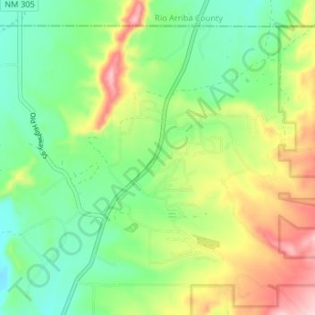
Name: Regina topographic map, elevation, terrain.

Location: Regina, Sandoval County, New Mexico, 87046, United States (36.17224 -106.97485 36.21659 -106.90928)

Average elevation: 2,309 m

Minimum elevation: 2,228 m

Maximum elevation: 2,447 m

Other topographic maps

Click on a map to view its topography, its elevation and its terrain.

Seven Springs

United States > New Mexico > Sandoval County

Average elevation: 2,538 m

La Cueva

United States > New Mexico > Sandoval County

Average elevation: 2,470 m

San Luis

United States > New Mexico > Sandoval County

Average elevation: 1,919 m

Placitas

United States > New Mexico > Sandoval County

Average elevation: 1,864 m

Redondo Peak

United States > New Mexico > Sandoval County

Average elevation: 3,193 m

Placitas

United States > New Mexico > Sandoval County

Average elevation: 1,864 m

Cabezon

United States > New Mexico > Sandoval County

Average elevation: 1,888 m

Gear up for your next adventure:

💡LED Camping Lantern - Illuminate your campsite with long-lasting lanterns
🍽️Titanium Camping Spork - Ultralight and indestructible eating utensil
🧭GPS Handheld Device - Reliable GPS navigation for outdoor adventures
🗺️Topographic Maps - Detailed maps to explore trails, mountains, and wilderness areas
🧴Insect Repellent - Protect yourself from bugs during outdoor adventures

As an Amazon Associate, this site earns from qualifying purchases at no extra cost to you.