
Big Pond topographic map
Click on the map to display elevation.
About this map
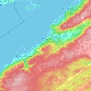
Name: Big Pond topographic map, elevation, terrain.
Average elevation: 75 m
Minimum elevation: -3 m
Maximum elevation: 192 m
Cape Breton Regional Municipality trails, hiking, mountain biking, running and outdoor activities
Other topographic maps
Click on a map to view its topography, its elevation and its terrain.
Victoria Bridge
Canada > Nova Scotia > Cape Breton Regional Municipality > Upper Grand Mira
Average elevation: 17 m
Salmon River Road
Canada > Nova Scotia > Cape Breton Regional Municipality > Grand Mira North
Average elevation: 18 m
Cranberry Lake
Canada > Nova Scotia > Cape Breton Regional Municipality > Enon
Average elevation: 103 m
Centreville
Canada > Nova Scotia > Cape Breton Regional Municipality > Sydney Mines
Average elevation: 12 m
Brown Islands
Canada > Nova Scotia > Cape Breton Regional Municipality > Main-à-Dieu
Average elevation: 0 m
Boisdale Hills
Canada > Nova Scotia > Cape Breton Regional Municipality > Northside East Bay
Average elevation: 104 m
Shunacadie
Canada > Nova Scotia > Cape Breton Regional Municipality > Shenacadie
Average elevation: 59 m
Derby Point
Canada > Nova Scotia > Cape Breton Regional Municipality > Pipers Cove
Average elevation: 22 m
Meadows Road
Canada > Nova Scotia > Cape Breton Regional Municipality > Sydney Forks
Average elevation: 23 m