
Hillside topographic map
Click on the map to display elevation.
About this map
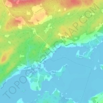
Name: Hillside topographic map, elevation, terrain.
Average elevation: 26 m
Minimum elevation: -3 m
Maximum elevation: 85 m
Cape Breton Regional Municipality trails, hiking, mountain biking, running and outdoor activities
Other topographic maps
Click on a map to view its topography, its elevation and its terrain.
Sydney
Canada > Nova Scotia > Cape Breton Regional Municipality
Sydney is on the east bank of the Sydney River where it discharges into South Arm of Sydney Harbour. Elevation ranges from sea level to 66 m (217 ft) above sea level.
Average elevation: 30 m
Boularderie Island
Canada > Nova Scotia > Cape Breton Regional Municipality > Southside Boularderie
Average elevation: 75 m
Brown Islands
Canada > Nova Scotia > Cape Breton Regional Municipality > Main-à-Dieu
Average elevation: 0 m
Mill Creek
Canada > Nova Scotia > Cape Breton Regional Municipality > Mill Creek
Average elevation: 26 m
Sydney
Canada > Nova Scotia > Cape Breton Regional Municipality
Sydney is on the east bank of the Sydney River where it discharges into South Arm of Sydney Harbour. Elevation ranges from sea level to 66 m (217 ft) above sea level.
Average elevation: 30 m
Sydney
Canada > Nova Scotia > Cape Breton Regional Municipality
Sydney is on the east bank of the Sydney River where it discharges into South Arm of Sydney Harbour. Elevation ranges from sea level to 66 m (217 ft) above sea level.
Average elevation: 30 m