
Make a donation
Gear up for your next adventure:
As an Amazon Associate, this site earns from qualifying purchases at no extra cost to you.
Aguada topographic map
Click on the map to display elevation.
Make a donation
Gear up for your next adventure:
As an Amazon Associate, this site earns from qualifying purchases at no extra cost to you.
Aguada
Aguada (Spanish pronunciation: [aˈɣwaða]) is a town and municipality in the Vélez Province of the Santander Department in northeastern Colombia. Aguada is located in the vicinity of the Opón River at an altitude of 1,700 metres (5,600 ft). It borders El Guacamayo in the north, San Benito in the south, Suaita in the east and La Paz in the west.
Make a donation
Gear up for your next adventure:
As an Amazon Associate, this site earns from qualifying purchases at no extra cost to you.
About this map
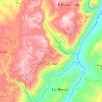
Name: Aguada topographic map, elevation, terrain.
Location: Aguada, Vélez, Santander, Colombia (6.10855 -73.57058 6.25122 -73.48249)
Average elevation: 1,635 m
Minimum elevation: 985 m
Maximum elevation: 2,289 m
Make a donation
Gear up for your next adventure:
As an Amazon Associate, this site earns from qualifying purchases at no extra cost to you.
Other topographic maps
Click on a map to view its topography, its elevation and its terrain.
Make a donation
Gear up for your next adventure:
As an Amazon Associate, this site earns from qualifying purchases at no extra cost to you.
Make a donation
Gear up for your next adventure:
As an Amazon Associate, this site earns from qualifying purchases at no extra cost to you.