Geolocate

North Slave Region topographic map

Click on the map to display elevation.

About this map

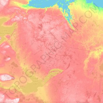
Name: North Slave Region topographic map, elevation, terrain.

Location: North Slave Region, Northwest Territories, Canada (61.88928 -121.23767 66.83784 -102.00062)

Average elevation: 305 m

Minimum elevation: -1 m

Maximum elevation: 880 m

Northwest Territories trails, hiking, mountain biking, running and outdoor activities

Other topographic maps

Click on a map to view its topography, its elevation and its terrain.

Mackenzie Mountains

Canada > Northwest Territories

Average elevation: 1,213 m

North Nahanni River

Canada > Northwest Territories

Average elevation: 1,449 m

Inuvik

Canada > Northwest Territories

Average elevation: 159 m

Peel River

Canada > Northwest Territories

Average elevation: 45 m

Wrigley

Canada > Northwest Territories > Dehcho Region

Average elevation: 159 m

Grace Lake

Canada > Northwest Territories > Yellowknife

Average elevation: 183 m

Déline

Canada > Northwest Territories > Sahtu Region

Average elevation: 193 m

Yellowknife

Canada > Northwest Territories > Yellowknife

Average elevation: 182 m

Gear up for your next adventure:

🛶Kayak Dry Bag - Waterproof storage for kayaking adventures
💧Hydration Pack - Hands-free hydration system for long hikes
🧼Travel Hand Sanitizer - Keep hands clean when water is scarce
🔦LED Headtorch - Bright and durable light for night activities
🚲MTB Frame Bag - Carry tools and maps directly on your bicycle frame

As an Amazon Associate, this site earns from qualifying purchases at no extra cost to you.