
National Capital District topographic map
Interactive map
Click on the map to display elevation.
About this map
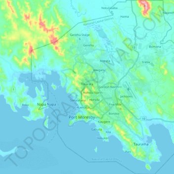
Name: National Capital District topographic map, elevation, terrain.
Location: National Capital District, Southern Region, Papua New Guinea (-9.54379 147.09765 -9.33246 147.29690)
Average elevation: 50 m
Minimum elevation: -1 m
Maximum elevation: 458 m
Other topographic maps
Click on a map to view its topography, its elevation and its terrain.
Autonomous Region of Bougainville
Autonomous Region of Bougainville, Islands Region, Papua New Guinea
Average elevation: 18 m
Suain
Suain, Sandaun, Momase Region, Papua New Guinea
Average elevation: 11 m
Eastern Highlands
Eastern Highlands, Highlands Region, Papua New Guinea
Average elevation: 1,498 m
Western Highlands
Western Highlands, Highlands Region, Papua New Guinea
Average elevation: 1,846 m
Lavongai
Papua New Guinea > New Ireland
Lavongai, New Ireland, Islands Region, Papua New Guinea
Average elevation: 43 m
Rabaul District
Papua New Guinea > East New Britain
Rabaul District, East New Britain, Islands Region, Papua New Guinea
Average elevation: 157 m
Port Moresby
Papua New Guinea > National Capital District > National Capital District
Port Moresby, National Capital District, Southern Region, 111, Papua New Guinea
Average elevation: 34 m
Lae
Papua New Guinea > Morobe > Lae District
Lae, Lae District, Morobe, Momase Region, Papua New Guinea
Average elevation: 162 m
Lokon
Papua New Guinea > New Ireland > Lokon
Lokon, New Ireland, Islands Region, Papua New Guinea
Average elevation: 38 m
Messi
Papua New Guinea > New Ireland > Messi
Messi, New Ireland, Islands Region, Papua New Guinea
Average elevation: 64 m
Bismarck Archipelago
Papua New Guinea > West New Britain
Bismarck Archipelago, West New Britain, Islands Region, Papua New Guinea
Average elevation: 0 m
Milne Bay District
Papua New Guinea > Milne Bay > Milne Bay District
Milne Bay District, Milne Bay, Southern Region, Papua New Guinea
Average elevation: 82 m
Pender Island
Pender Island, Milne Bay, Southern Region, Papua New Guinea
Average elevation: 2 m
Angoram
Papua New Guinea > East Sepik > Angoram
Angoram, Angoram District, East Sepik, Momase Region, Papua New Guinea
Average elevation: 11 m
D'Entrecasteaux Islands
D'Entrecasteaux Islands, Milne Bay, Papua Region, Papua New Guinea
Average elevation: 76 m
Pak Island
Pak Island, Manus District, Manus, Islands Region, Papua New Guinea
Average elevation: 2 m
Manus
Manus, Manus District, Manus, Islands Region, Papua New Guinea
Average elevation: 18 m
D’Entrecasteaux Islands
D’Entrecasteaux Islands, Esa’ala District, Milne Bay, Papua Region, Papua New Guinea
Average elevation: 102 m
Gulf of Papua
Gulf of Papua, Kerema District, Gulf, Papua Region, Papua New Guinea
Average elevation: 394 m
Goodenough Island
Goodenough Island, Esa’ala District, Milne Bay, Papua Region, Papua New Guinea
Average elevation: 103 m
Normanby Island
Normanby Island, Esa’ala District, Milne Bay, Papua Region, Papua New Guinea
Average elevation: 49 m
Tagula Island
Tagula Island, Misima District, Milne Bay, Papua Region, Papua New Guinea
Average elevation: 18 m
Buka Island
Papua New Guinea > Bougainville
Buka Island, Buka District, Bougainville, Islands Region, Papua New Guinea
Average elevation: 8 m
New Ireland
Papua New Guinea > New Ireland
New Ireland, Islands Region, Papua New Guinea
Average elevation: 83 m
Woodlark Island
Woodlark Island, Losuia District, Milne Bay, Papua Region, Papua New Guinea
Average elevation: 9 m
Fergusson Island
Fergusson Island, Esa’ala District, Milne Bay, Papua Region, Papua New Guinea
Average elevation: 98 m
Owen Stanley Range
Owen Stanley Range, Port Moresby District, Central, Papua Region, Papua New Guinea
Average elevation: 2,450 m
Umboi Island
Umboi Island, Finschhafen District, Morobe, Momase Region, Papua New Guinea
Average elevation: 177 m
Bougainville Island
Papua New Guinea > Bougainville
Bougainville Island, Buka District, Bougainville, Islands Region, Papua New Guinea
Average elevation: 396 m