
Pender Island topographic map
Interactive map
Click on the map to display elevation.
About this map
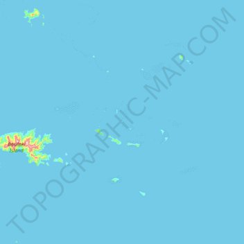
Name: Pender Island topographic map, elevation, terrain.
Average elevation: 2 m
Minimum elevation: 0 m
Maximum elevation: 453 m
Other topographic maps
Click on a map to view its topography, its elevation and its terrain.
Milne Bay District
Papua New Guinea > Milne Bay > Milne Bay District
Milne Bay District, Milne Bay, Southern Region, Papua New Guinea
Average elevation: 82 m
D'Entrecasteaux Islands
D'Entrecasteaux Islands, Milne Bay, Papua Region, Papua New Guinea
Average elevation: 76 m
D’Entrecasteaux Islands
D’Entrecasteaux Islands, Esa’ala District, Milne Bay, Papua Region, Papua New Guinea
Average elevation: 102 m
Goodenough Island
Goodenough Island, Esa’ala District, Milne Bay, Papua Region, Papua New Guinea
Average elevation: 103 m
Normanby Island
Normanby Island, Esa’ala District, Milne Bay, Papua Region, Papua New Guinea
Average elevation: 49 m
Tagula Island
Tagula Island, Misima District, Milne Bay, Papua Region, Papua New Guinea
Average elevation: 18 m
Woodlark Island
Woodlark Island, Losuia District, Milne Bay, Papua Region, Papua New Guinea
Average elevation: 9 m
Fergusson Island
Fergusson Island, Esa’ala District, Milne Bay, Papua Region, Papua New Guinea
Average elevation: 98 m