
Make a donation
Gear up for your next adventure:
As an Amazon Associate, this site earns from qualifying purchases at no extra cost to you.
Oggebbio topographic map
Click on the map to display elevation.
Make a donation
Gear up for your next adventure:
As an Amazon Associate, this site earns from qualifying purchases at no extra cost to you.
Oggebbio
Oggebbio ist die topografische Bezeichnung für 15 Dörfer, die verstreut in den Bergen bis hinunter zum Seeufer liegen. Der Gemeindesitz befindet sich in dem Ortsteil Gonte. Über diesen Dörfern liegen die acht Almen von Oggebbio, „Sommerdörfer“, die bis auf 1075 m s.l.m. Höhe reichen. Zur Gemeinde Oggebbio gehören die Fraktionen Barbè, Cadessino, Camogno, Gonte, Manegra, Novaglio, Piancavallo, Piazza, Pieggio, Quarcino, Rancone, Resiga, Spasolo und Travallino und Dumera.
Make a donation
Gear up for your next adventure:
As an Amazon Associate, this site earns from qualifying purchases at no extra cost to you.
About this map
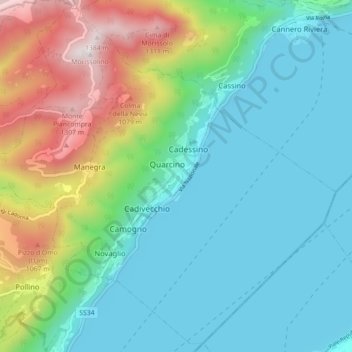
Name: Oggebbio topographic map, elevation, terrain.
Location: Oggebbio, Verbano-Cusio-Ossola, Piemont, Italien (45.96619 8.60208 46.02485 8.69056)
Average elevation: 500 m
Minimum elevation: 185 m
Maximum elevation: 1,388 m
Make a donation
Gear up for your next adventure:
As an Amazon Associate, this site earns from qualifying purchases at no extra cost to you.
Other topographic maps
Click on a map to view its topography, its elevation and its terrain.
Westalpen
Italien > Piemont > Verbano-Cusio-Ossola > Ceppo Morelli
Die Westalpen enthalten die gesamten Alpenanteile von Frankreich und Monaco, den größten der Schweiz, sowie einen nicht unbeträchtlichen von Italien, und sind insgesamt deutlich höher als die Ostalpen – 81 der insgesamt 82 Viertausender der Alpen liegen in den Westalpen, und damit auch die 64 höchsten…
Average elevation: 2,662 m
Make a donation
Gear up for your next adventure:
As an Amazon Associate, this site earns from qualifying purchases at no extra cost to you.
Valdo / Wald
Italien > Piemont > Verbano-Cusio-Ossola > Pomatt > Ponte / Zum Schtäg
Average elevation: 1,843 m
Make a donation
Gear up for your next adventure:
As an Amazon Associate, this site earns from qualifying purchases at no extra cost to you.
Mottarone
Italien > Piemont > Verbano-Cusio-Ossola > Stresa
Der Berg ist seit 1970 durch die zweiteilige Luftseilbahn „Funivia Stresa-Alpino-Mottarone“ erschlossen, die von der Baufirma Impresa Poscio und der Bahnbaufirma Piemonte Funivie in Turin errichtet wurde. Von Oktober 2014 bis 12. August 2016 war der Betrieb wegen Instandsetzungsarbeiten eingestellt. Die…
Average elevation: 1,177 m
Make a donation
Gear up for your next adventure:
As an Amazon Associate, this site earns from qualifying purchases at no extra cost to you.
Fontana dell' Albi
Italien > Piemont > Verbano-Cusio-Ossola > Pieve Vergonte
Average elevation: 1,344 m
Make a donation
Gear up for your next adventure:
As an Amazon Associate, this site earns from qualifying purchases at no extra cost to you.
Make a donation
Gear up for your next adventure:
As an Amazon Associate, this site earns from qualifying purchases at no extra cost to you.
Alpe Corti
Italien > Piemont > Verbano-Cusio-Ossola > Montescheno > Alpi Faiu
Average elevation: 1,274 m
Make a donation
Gear up for your next adventure:
As an Amazon Associate, this site earns from qualifying purchases at no extra cost to you.