Geolocate

Fügen topographic map

Click on the map to display elevation.

About this map

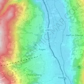
Name: Fügen topographic map, elevation, terrain.

Location: Fügen, Bezirk Schwaz, Tyrol, Austria (47.32379 11.82968 47.37029 11.86627)

Average elevation: 771 m

Minimum elevation: 524 m

Maximum elevation: 1,426 m

Other topographic maps

Click on a map to view its topography, its elevation and its terrain.

Hochwartspitze

Austria > Tyrol > Bezirk Schwaz > Tux

Average elevation: 2,182 m

Hintertux

Austria > Tyrol > Bezirk Schwaz

Average elevation: 1,949 m

Zillertal

Austria > Tyrol > Bezirk Schwaz > Kaltenbach

Average elevation: 1,499 m

Juns

Austria > Tyrol > Bezirk Schwaz

Average elevation: 1,752 m

Kumbichl

Austria > Tyrol > Bezirk Schwaz > Mayrhofen

Average elevation: 1,046 m

Maurach

Austria > Tyrol > Bezirk Schwaz > Eben am Achensee

Average elevation: 1,197 m

Hintertux

Austria > Tyrol > Bezirk Schwaz

Average elevation: 1,949 m

Mitteremberg

Austria > Tyrol > Bezirk Schwaz > Kaltenbach

Average elevation: 928 m

Loach

Austria > Tyrol > Bezirk Schwaz > Ahrnbach

Average elevation: 839 m

Pertisau

Austria > Tyrol > Bezirk Schwaz > Eben am Achensee

Average elevation: 1,141 m

Ginzling

Austria > Tyrol > Bezirk Schwaz > Mayrhofen

Average elevation: 1,564 m

Fügen

Austria > Tyrol > Bezirk Schwaz > Gemeinde Fügen

Average elevation: 737 m

Zillertal

Austria > Tyrol > Bezirk Schwaz > Kaltenbach

Average elevation: 1,499 m

Geier

Austria > Tyrol > Bezirk Schwaz > Gemeinde Tux

Average elevation: 2,502 m

Gear up for your next adventure:

🧢Beanie Hat - Keep your head warm in cold weather
🧴Insect Repellent - Protect yourself from bugs during outdoor adventures
Tent Footprint - Protect tent floor and increase durability
🧭GPS Handheld Device - Reliable GPS navigation for outdoor adventures
🐕Hiking Dog Pack - Let your canine companion carry their own water and food

As an Amazon Associate, this site earns from qualifying purchases at no extra cost to you.