Geolocate

Lindale topographic map

Click on the map to display elevation.

About this map

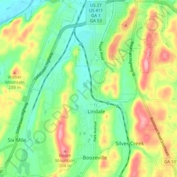
Name: Lindale topographic map, elevation, terrain.

Location: Lindale, Floyd County, Georgia, 30147, United States (34.16508 -85.20581 34.22343 -85.15845)

Average elevation: 229 m

Minimum elevation: 176 m

Maximum elevation: 312 m

Other topographic maps

Click on a map to view its topography, its elevation and its terrain.

Radio Springs

United States > Georgia > Floyd County

Average elevation: 243 m

Cave Spring

United States > Georgia > Floyd County

Average elevation: 237 m

Berryhill

United States > Georgia > Floyd County > Rome

Average elevation: 207 m

Gear up for your next adventure:

🔋Lithium AA Batteries - Long-lasting power that performs in extreme cold
🛶Kayak Accessories - Essential gear for safe and fun kayaking adventures
🛁Quick-Dry Microfiber Towel - Space-saving towel that dries rapidly on the move
🛶Kayak Dry Bag - Waterproof storage for kayaking adventures
🥾Mountain Hiking Shoes - Shoes with superior grip for mountainous terrain

As an Amazon Associate, this site earns from qualifying purchases at no extra cost to you.