
Make a donation
Gear up for your next adventure:
As an Amazon Associate, this site earns from qualifying purchases at no extra cost to you.
Hademstorf topographic map
Click on the map to display elevation.
Make a donation
Gear up for your next adventure:
As an Amazon Associate, this site earns from qualifying purchases at no extra cost to you.
About this map
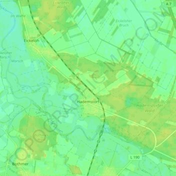
Name: Hademstorf topographic map, elevation, terrain.
Average elevation: 26 m
Minimum elevation: 19 m
Maximum elevation: 32 m
Make a donation
Gear up for your next adventure:
As an Amazon Associate, this site earns from qualifying purchases at no extra cost to you.
Other topographic maps
Click on a map to view its topography, its elevation and its terrain.
Lüneburger Heide
Deutschland > Niedersachsen > Heidekreis > Soltau > Hötzingen > Emhof
Average elevation: 85 m
Make a donation
Gear up for your next adventure:
As an Amazon Associate, this site earns from qualifying purchases at no extra cost to you.
Make a donation
Gear up for your next adventure:
As an Amazon Associate, this site earns from qualifying purchases at no extra cost to you.
Schülernbrockhof
Deutschland > Niedersachsen > Heidekreis > Schneverdingen > Schülern
Average elevation: 73 m
Make a donation
Gear up for your next adventure:
As an Amazon Associate, this site earns from qualifying purchases at no extra cost to you.
Make a donation
Gear up for your next adventure:
As an Amazon Associate, this site earns from qualifying purchases at no extra cost to you.
Make a donation
Gear up for your next adventure:
As an Amazon Associate, this site earns from qualifying purchases at no extra cost to you.
Make a donation
Gear up for your next adventure:
As an Amazon Associate, this site earns from qualifying purchases at no extra cost to you.
Make a donation
Gear up for your next adventure:
As an Amazon Associate, this site earns from qualifying purchases at no extra cost to you.
Make a donation
Gear up for your next adventure:
As an Amazon Associate, this site earns from qualifying purchases at no extra cost to you.
Make a donation
Gear up for your next adventure:
As an Amazon Associate, this site earns from qualifying purchases at no extra cost to you.
Groß Häuslingen
Deutschland > Niedersachsen > Heidekreis
Die erste Besiedlung wurde im Bereich des Hunnenberges nachgewiesen. Bei dem Hunnenberg handelt es sich um eine Binnenlanddüne. Nach Heinrich Imhagen, dem ehemaligen Lehrer und Ortschronisten, bedeutet dieser Name „Pfahlhausheim“ oder auch „Hügelhausheim“. Dieses mag darin begründet liegen, dass der…
Average elevation: 20 m
Make a donation
Gear up for your next adventure:
As an Amazon Associate, this site earns from qualifying purchases at no extra cost to you.
Make a donation
Gear up for your next adventure:
As an Amazon Associate, this site earns from qualifying purchases at no extra cost to you.
Make a donation
Gear up for your next adventure:
As an Amazon Associate, this site earns from qualifying purchases at no extra cost to you.
Make a donation
Gear up for your next adventure:
As an Amazon Associate, this site earns from qualifying purchases at no extra cost to you.
Make a donation
Gear up for your next adventure:
As an Amazon Associate, this site earns from qualifying purchases at no extra cost to you.
Make a donation
Gear up for your next adventure:
As an Amazon Associate, this site earns from qualifying purchases at no extra cost to you.
Steinbeck (Luhe)
Deutschland > Niedersachsen > Heidekreis
Der Ortskern von Steinbeck befindet sich an einer Erhebung fünf Kilometer nordöstlich von Bispingen. Die Anwesen und Gebäude verteilen sich hauptsächlich auf einer Länge von etwa drei Kilometern entlang der Hauptstraße, die Steinbeck im Westen mit Hützel und im Osten mit Schwindebeck verbindet. Diese…
Average elevation: 85 m
Make a donation
Gear up for your next adventure:
As an Amazon Associate, this site earns from qualifying purchases at no extra cost to you.
Rethem (Aller)
Deutschland > Niedersachsen > Heidekreis > Rethem (Aller) > Rethem (Aller)
Average elevation: 20 m
Rethemer Fähre
Deutschland > Niedersachsen > Heidekreis > Kirchwahlingen > Rethemer Fähre
Average elevation: 20 m
Make a donation
Gear up for your next adventure:
As an Amazon Associate, this site earns from qualifying purchases at no extra cost to you.
Zahrensen
Deutschland > Niedersachsen > Heidekreis > Schneverdingen > Zahrensen
Average elevation: 71 m
Emmingen
Deutschland > Niedersachsen > Heidekreis > Soltau
Emmingen hat 46 Einwohner, liegt auf einer Höhe von 83 Metern. Der Weiler hat sich aus einer Hofanlage entwickelt. und hatte einen Bahnhof an der Bahnstrecke Uelzen–Langwedel.
Average elevation: 86 m
Make a donation
Gear up for your next adventure:
As an Amazon Associate, this site earns from qualifying purchases at no extra cost to you.
Im Katzhagen
Deutschland > Niedersachsen > Heidekreis > Osterheide > Ostenholz
Average elevation: 49 m
Make a donation
Gear up for your next adventure:
As an Amazon Associate, this site earns from qualifying purchases at no extra cost to you.
Wintermoor an der Chaussee
Deutschland > Niedersachsen > Heidekreis > Schneverdingen
Average elevation: 61 m
Make a donation
Gear up for your next adventure:
As an Amazon Associate, this site earns from qualifying purchases at no extra cost to you.
Lüneburger Heide
Deutschland > Niedersachsen > Heidekreis > Soltau > Hötzingen > Emhof
Average elevation: 85 m