
Make a donation
Gear up for your next adventure:
As an Amazon Associate, this site earns from qualifying purchases at no extra cost to you.
Borg topographic map
Click on the map to display elevation.
Make a donation
Gear up for your next adventure:
As an Amazon Associate, this site earns from qualifying purchases at no extra cost to you.
About this map
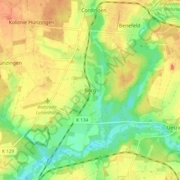
Name: Borg topographic map, elevation, terrain.
Location: Borg, Walsrode, Heidekreis, Niedersachsen, 29699, Deutschland (52.87151 9.60077 52.91151 9.64077)
Average elevation: 52 m
Minimum elevation: 29 m
Maximum elevation: 72 m
Make a donation
Gear up for your next adventure:
As an Amazon Associate, this site earns from qualifying purchases at no extra cost to you.
Other topographic maps
Click on a map to view its topography, its elevation and its terrain.
Düshorn
Deutschland > Niedersachsen > Heidekreis > Walsrode
In einer Beschreibung des ehemaligen Heimatpflegers des Kreises Fallingbostel, Hans Stuhlmacher (Schneeheide) wird der Ortsname so gedeutet: Düshorn wurde im Jahre 1227 erstmals urkundlich erwähnt, und zwar als Dushorne. In dem alten Ortsnamen steht „Dus“ für „düster“, „horn“ für Anhöhe,…
Average elevation: 45 m
Make a donation
Gear up for your next adventure:
As an Amazon Associate, this site earns from qualifying purchases at no extra cost to you.
Nordkampen
Deutschland > Niedersachsen > Heidekreis > Walsrode
Der Ort wurde zusammen mit Südkampen erstmals 1255 in der Urkunde Nr. 43 des Walsroder Klosters erwähnt. Ein Feld bzw. Ackerland (lat. campus) führte zur Namensgebung dieser Dörfer. Die Himmelsrichtungen Nord bzw. Süd veranschaulichen die topografische Trennung. Früher gab es auch die Bezeichnungen…
Average elevation: 43 m
Make a donation
Gear up for your next adventure:
As an Amazon Associate, this site earns from qualifying purchases at no extra cost to you.
Make a donation
Gear up for your next adventure:
As an Amazon Associate, this site earns from qualifying purchases at no extra cost to you.