
Make a donation
Gear up for your next adventure:
As an Amazon Associate, this site earns from qualifying purchases at no extra cost to you.
Emmingen topographic map
Click on the map to display elevation.
Make a donation
Gear up for your next adventure:
As an Amazon Associate, this site earns from qualifying purchases at no extra cost to you.
Emmingen
Emmingen hat 46 Einwohner, liegt auf einer Höhe von 83 Metern. Der Weiler hat sich aus einer Hofanlage entwickelt. und hatte einen Bahnhof an der Bahnstrecke Uelzen–Langwedel.
Make a donation
Gear up for your next adventure:
As an Amazon Associate, this site earns from qualifying purchases at no extra cost to you.
About this map
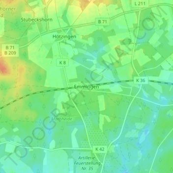
Name: Emmingen topographic map, elevation, terrain.
Location: Emmingen, Soltau, Heidekreis, Niedersachsen, Deutschland (52.97929 9.95865 53.01929 9.99865)
Average elevation: 86 m
Minimum elevation: 74 m
Maximum elevation: 108 m
Make a donation
Gear up for your next adventure:
As an Amazon Associate, this site earns from qualifying purchases at no extra cost to you.
Other topographic maps
Click on a map to view its topography, its elevation and its terrain.