Geolocate

Bryan topographic map

Click on the map to display elevation.

About this map

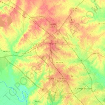
Name: Bryan topographic map, elevation, terrain.

Location: Bryan, Brazos County, Texas, United States (30.58460 -96.51692 30.74052 -96.24502)

Average elevation: 92 m

Minimum elevation: 57 m

Maximum elevation: 129 m

Other topographic maps

Click on a map to view its topography, its elevation and its terrain.

Rye

United States > Texas > Brazos County

Average elevation: 87 m

Stone City

United States > Texas > Brazos County

Average elevation: 75 m

Union

United States > Texas > Brazos County

Average elevation: 97 m

Royder

United States > Texas > Brazos County

Average elevation: 94 m

Nelleva

United States > Texas > Brazos County

Average elevation: 84 m

Wicker

United States > Texas > Brazos County > College Station

Average elevation: 94 m

Gear up for your next adventure:

🧥Waterproof Jacket - Lightweight rain jackets for hiking and outdoor activities
🍽️Titanium Camping Spork - Ultralight and indestructible eating utensil
🥾Hiking Boots - Sturdy boots providing ankle support and traction on rugged trails
🥾Hiking Leggings - Comfortable leggings for outdoor activities
🎒Hiking Backpack - Lightweight and ergonomic backpacks for day hikes or multi-day treks

As an Amazon Associate, this site earns from qualifying purchases at no extra cost to you.