Geolocate

Kaxholmen topographic map

Click on the map to display elevation.

About this map

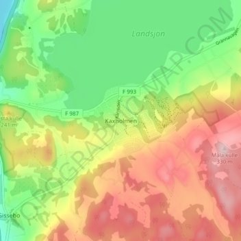
Name: Kaxholmen topographic map, elevation, terrain.

Location: Kaxholmen, Jönköpings kommun, 561 46, Sweden (57.83400 14.28759 57.87400 14.32759)

Average elevation: 200 m

Minimum elevation: 86 m

Maximum elevation: 330 m

Other topographic maps

Click on a map to view its topography, its elevation and its terrain.

Skåne County

Sweden

Average elevation: 44 m

Östergötland County

Sweden

Average elevation: 83 m

Scandinavia

Sweden

Average elevation: 125 m

Möckeln

Sweden > Kronoberg County > Pjätteryd

Average elevation: 142 m

Lund

Sweden > Skåne County

Average elevation: 42 m

Hallsbergs kommun

Sweden > Örebro County

Average elevation: 92 m

Töfsingdalen

Sweden > Dalarna County

Average elevation: 817 m

Jokkmokks kommun

Sweden > Norrbotten County

Average elevation: 538 m

Dorotea kommun

Sweden > Västerbotten County

Average elevation: 449 m

Västanå

Sweden > Jönköping County > Gränna

Average elevation: 136 m

Alnön

Sweden > Västernorrland County

Average elevation: 32 m

Brännö

Sweden > Västra Götaland County > Brännö

Average elevation: 6 m

Lund

Sweden > Skåne County

Average elevation: 42 m

Bergs kommun

Sweden > Jämtland County

Average elevation: 575 m

Örkelljunga kommun

Sweden > Skåne County

Average elevation: 105 m

Leksands kommun

Sweden > Dalarna County

Average elevation: 255 m

Malmö

Sweden > Skåne County

Average elevation: 10 m

Gotland

Sweden

Average elevation: 6 m

Fäberga naturreservat

Sweden > Halland County > Halmstad > Ryd

Average elevation: 38 m

Gamla stan

Sweden > Stockholm County > Stockholm

Average elevation: 19 m

Sarek

Sweden

Sarek National Park is the most mountainous region in Sweden and it is the part of the country that mostly resembles an alpine countryside. Within the park are 19 summits higher than 1,900 m (6,200 ft), the most noted being the second highest summit in Sweden after the Kebnekaise – the Sarektjåkkå with a…

Average elevation: 994 m

Kronoberg County

Sweden

Average elevation: 154 m

Storumans kommun

Sweden > Västerbotten County

Average elevation: 588 m

Gotland

Sweden

Average elevation: 6 m

Västmanland County

Sweden

Average elevation: 75 m

Umeå

Sweden > Västerbotten County

Average elevation: 33 m

Pajala kommun

Sweden > Norrbotten County

Average elevation: 262 m

Södermalm

Sweden > Stockholm County > Stockholm

Average elevation: 22 m

Sundsvall

Sweden > Västernorrland County

Average elevation: 70 m

Storsjön

Sweden > Jämtland County

Average elevation: 404 m

Ven

Sweden > Skåne County

Along the entire coast, the island drops steeply towards the sea where the Öresund meets a rocky beach. This steep coast is called Backafall. Ven's backafall is a nature reserve established in 1990. There are no large forests, but smaller stands of trees occur closest to the coast the slightly higher…

Average elevation: 13 m

Kjolen

Sweden > Stockholm County > Stockholm

Average elevation: 39 m

Sigtuna kommun

Sweden > Stockholm County

Average elevation: 26 m

Gotland

Sweden

Average elevation: 6 m

Mora kommun

Sweden > Dalarna County

Average elevation: 384 m

Hallandsåsen

Sweden

Average elevation: 71 m

South Sweden

Sweden

Average elevation: 45 m

Kebnekaise

Sweden > Norrbotten County

Average elevation: 1,307 m

Jämtland County

Sweden

Average elevation: 453 m

Botkyrka kommun

Sweden > Stockholm County

Average elevation: 41 m

Dalarna County

Sweden

Average elevation: 381 m

Arvidsjaurs kommun

Sweden > Norrbotten County

Average elevation: 388 m

Gotland

Sweden

Average elevation: 6 m

Värmland County

Sweden

Average elevation: 218 m

Kalmar County

Sweden

Average elevation: 62 m

Ven

Sweden > Skåne County > Tuna

Along the entire coast, the island drops steeply towards the sea where the Öresund meets a rocky beach. This steep coast is called Backafall. Ven's backafall is a nature reserve established in 1990. There are no large forests, but smaller stands of trees occur closest to the coast the slightly higher…

Average elevation: 13 m

Fagersta kommun

Sweden > Västmanland County

Average elevation: 131 m

Kullaberg

Sweden > Skåne County > Mölle

Kullaberg (Swedish pronunciation: [kɵlaˈbærj]) is a peninsula and nature reserve of land protruding into the Kattegat in Höganäs Municipality near the town of Mölle in southwest Sweden. The site in the province of Skåne is an area of considerable biodiversity supporting a number of rare species and has…

Average elevation: 22 m

Province of Uppland

Sweden

Average elevation: 28 m

Malingsbo-Kloten

Sweden > Örebro County

Average elevation: 274 m

North Sweden

Sweden

Average elevation: 244 m

Orust kommun

Sweden > Västra Götaland County

Average elevation: 36 m

Marks kommun

Sweden > Västra Götaland County

Average elevation: 126 m

Helgasjön

Sweden > Kronoberg County > Åby

Average elevation: 173 m

Gällivare kommun

Sweden > Norrbotten County

Average elevation: 486 m

Värmdö kommun

Sweden > Stockholm County

Average elevation: 2 m

Torneträsk

Sweden > Norrbotten County

Permafrost is common in the land around the lake. This low elevation permafrost is disappearing because of global warming and increased snowfall.

Average elevation: 768 m

Kebnekaise

Sweden > Norrbotten County

Average elevation: 1,658 m

Kramfors kommun

Sweden > Västernorrland County

Average elevation: 163 m

Kallebäck

Sweden > Västra Götaland County

Average elevation: 52 m

Muskö

Sweden > Stockholm County > Muskö

Average elevation: 8 m

Hammarö kommun

Sweden > Värmland County

Average elevation: 45 m

Gnesta kommun

Sweden > Södermanland County

Average elevation: 42 m

Malmö kommun

Sweden > Skåne County

Average elevation: 13 m

Province of Norrbotten

Sweden

Average elevation: 227 m

Klippans kommun

Sweden > Skåne County

Average elevation: 75 m

Halland County

Sweden

Average elevation: 90 m

Kiruna kommun

Sweden > Norrbotten County

Average elevation: 620 m

Täby kommun

Sweden > Stockholm County

Average elevation: 21 m

Region Götaland

Sweden

Average elevation: 51 m

Nybro kommun

Sweden > Kalmar County

Average elevation: 109 m

Västra Götaland County

Sweden

Average elevation: 97 m

Arjeplogs kommun

Sweden > Norrbotten County

Average elevation: 680 m

Province of Västergötland

Sweden

Average elevation: 126 m

Dorotea kommun

Sweden > Västerbotten County

Average elevation: 449 m

Skellefteå

Sweden > Västerbotten County

Average elevation: 49 m

Province of Småland

Sweden

Average elevation: 122 m

Blekinge County

Sweden

Average elevation: 38 m

Viggsö

Sweden > Stockholm County > Stagneudd

Average elevation: 5 m

Skåne County

Sweden

Average elevation: 44 m

Abisko National Park

Sweden > Norrbotten County

Permafrost is common in the national park, though permafrost at lower elevations is disappearing because of global warming and increased snowfall.

Average elevation: 740 m

Norrbotten County

Sweden

Average elevation: 409 m

Skellefteå

Sweden > Västerbotten County

Average elevation: 49 m

Sundbybergs kommun

Sweden > Stockholm County

Average elevation: 18 m

Gävle

Sweden > Gävleborg County

Average elevation: 28 m

Region Svealand

Sweden

Svealand consists of the capital region Mälardalen in the east, Roslagen in the north-east, the former mining district Bergslagen in the center, and Dalarna and Värmland in the west. It includes an extensive archipelago of thousands of small islands in Södermanland and Uppland and has lakeshores on the four…

Average elevation: 236 m

Tyresö kommun

Sweden > Stockholm County

Average elevation: 3 m

Ljusnan

Sweden

Average elevation: 372 m

Kils kommun

Sweden > Värmland County

Average elevation: 104 m

Province of Uppland

Sweden

Average elevation: 28 m

Gotland Municipality

Sweden > Gotland County

Average elevation: 2 m

Umnässjön

Sweden > Västerbotten County > Umnäs

Average elevation: 441 m

Padjelanta

Sweden

Average elevation: 824 m

Sarek

Sweden

Sarek National Park is the most mountainous region in Sweden and it is the part of the country that mostly resembles an alpine countryside. Within the park are 19 summits higher than 1,900 m (6,200 ft), the most noted being the second highest summit in Sweden after the Kebnekaise – the Sarektjåkkå with a…

Average elevation: 994 m

Kalmar County

Sweden

Average elevation: 62 m

Lund

Sweden > Skåne County

Average elevation: 42 m

Gear up for your next adventure:

🔥Camping Stove - Portable stoves to cook outdoors with ease
🔪Outdoor Multitool - Versatile tool for repairs and food prep in the wild
🥾Hiking Gaiters - Protect legs and shoes from mud, snow, and debris
🧥Thermal Fleece Jacket - Versatile insulation for changing mountain temperatures
🥾Trekking Boots - Durable boots for long-distance trekking

As an Amazon Associate, this site earns from qualifying purchases at no extra cost to you.